
About this page
Equipment required to receive marine weather forecasts and warnings on board a yacht or motorboat. Weather itself is complicated and so are the systems for delivering weather information. As I see it the various possible systems are listed below -
Related pages
On this page -
Communications areas
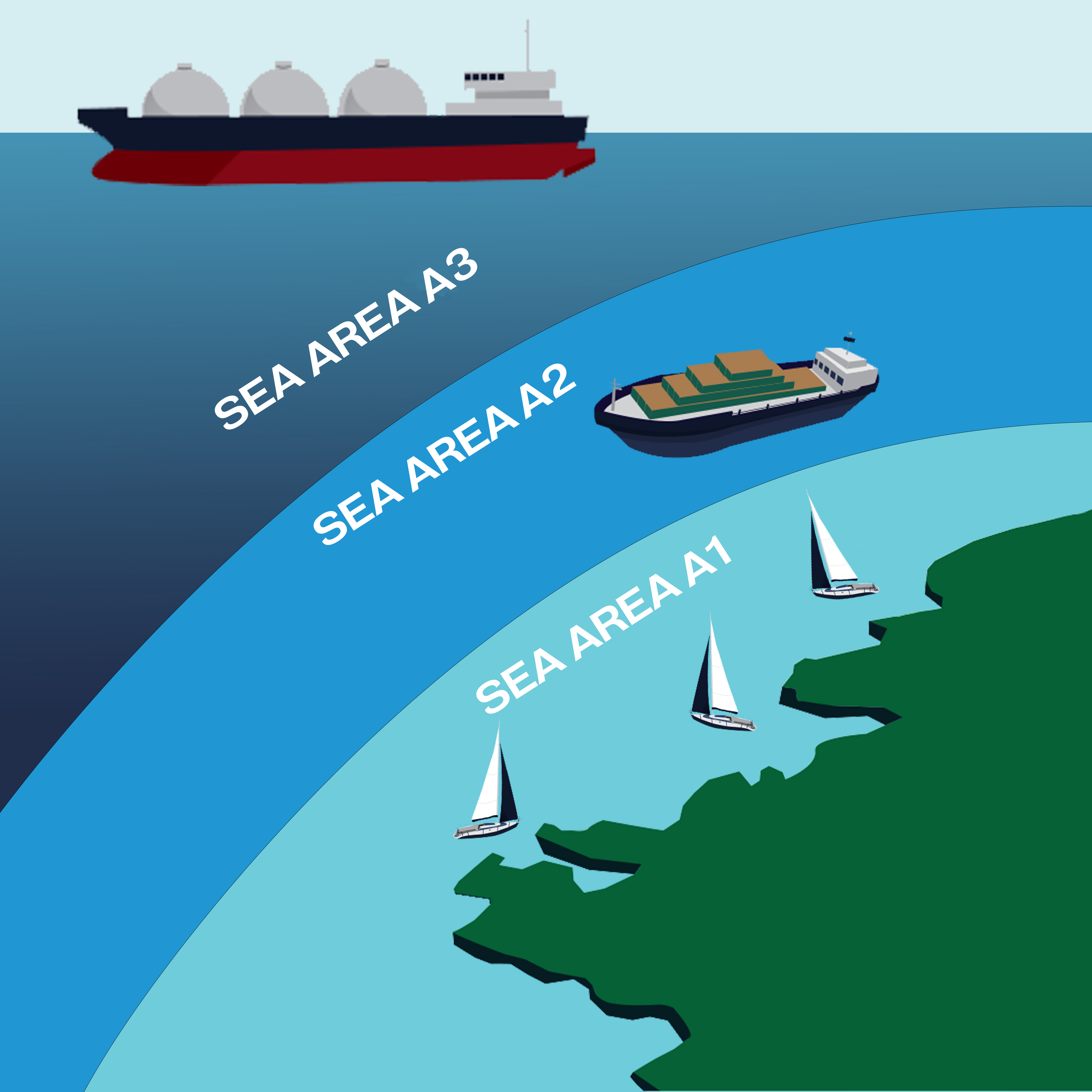
Courtesy of iCOM.
Vessels within area A1 are within VHF range of shore stations. Area A2 is within MF range. Area A3 is between about 65° deg N/S. Communications are via geostationary satellite and HF/SSB radio. A fourth area is A4, between latitude 65° deg and the poles. This is covered by terrestrial radio and polar orbiting satellites.
VHF
Used for communication of weather and other Marine Safety Information from MRCCs within area A1. Range is limited by line of sight. The signal is prone to being blocked by high ground or large structures – not a problem at sea.
VHF weather broadcasts are normally of inshore waters forecasts but may also include some forecasts for open sea areas. See another page for VHF schedules.
Broadcasts are usually in the local language although some countries have English language versions. There is often little problem in learning the basic terms and these can be found in almanacs and the CA Ten Language Dictionary. For those who worry about the language, I have a comprehensive list of French weather terms on another page.
NAVTEX
This MF/SSB (Single Side Band) radio system is a component of the GMDSS. It is designed for use from the fairway buoy out to about 200 NM, area A2, although it can often be received further out. See other pages for NAVTEX schedules, and Reception problems.
NAVTEX usually provides twice-daily 24 hour forecasts with a brief outlook that should be for a further 24 hours. It provides forecasts for offshore areas .
The international 518 kHz frequency broadcasts are always available in English. The secondary frequency of 490 kHz is used for national purposes. The UK and Germany, exceptionally at present, use the 490 hHz frequency for inshore waters forecasts.
In 2020, the USCG announced that they were considering discontinuing NAVTEX in favour of a satellite based system. Watch this space,
Inmarsat-C and Iridium
To some extent, these are an open ocean version of NAVTEX but with receive/transmit capability. Transmissions are from geostationary satellites. For Inmarsat, this limits reception to latitudes equator-wards of about 60 – 65 degrees. This is Area A3. Although rather expensive, Inmarsat-C can also be used to send (slowly) text messages and emails. Iridium use satellites in near polar orbits that cover the entire globe, Areas A3 and A4. It also has faster speeds than Inmarsat.
The weather information provided is a 24 hour forecast and a brief outlook for a further 24 – 36 hours. Areas covered are for the open ocean, eg the UK North Atlantic bulletin. The French term is "bulletins au grand large".
RadioTeletype
RTTY is a HF/SSB long range radio system used by the German weather service, DWD and the US Coast Guard as SITOR (Simplex Teletype over Radio). The technology is old and speeds are slow. For more, see my Radio Teletype Page.
Radio Facsimile
This is another old system that uses HF/SSB to broadcast weather charts. Either a computer and software is needed or a dedicated receiver/decoder. Transmissions are very slow and it can take 20 minutes to receive a chart. Radio fax schedules can be found in the DWD s chedule and the WMO General communications page publication.
Although it can be useful, and I have found it so, it has been largely superseded by alternative delivery systems and techniques. These include Internet web pages and the use of email and GRIB coded products.
National and Local Radio
Use of national radio very obviously depends upon ability to comprehend the language. The BBC shipping forecast is, arguably, one of the most useful simply because it is updated on a 6-hourly basis. The German Public service radio broadcasts in German are exceptionally clear and easy to understand.
Local radio, in the UK at least, is a variable feast. Much depends on the interest of the local station controller and staff. Schedules and content can vary at no or short notice. Not to be relied upon. Services are becoming digital (DAB.)
Telephone and Data networks
Use of conventional telephone has largely been largely superseded by 3G data networks accessed by PCs, Tablets or Smartphones. These enable reception of text forecasts, GRIB files and charts. .
Otherwise, the main use of telephones will be to use “Speak to a forecaster” services. Recorded voice and SMS services are virtually non-existent in the UK and will become rare generally.
So, what do I need?
For all sailors, VHF and NAVTEX should be regarded as necessary because these are the systems put in place under the GMDSS for the dissemination of MSI. If you are always near the coast then NAVTEX may not be strictly necessary. It can always be a useful back-up and as a source of NAV warnings.
For blue water sailors, one or both of Inmarsat and HF/SSB radio will enable reception of GMDSS services. Pgaes on RTTY and RadioFax might help.
See also the page on Radio Communications.
Increasingly, the Internet will be used as a means of accessing the same information. Equipment used will depend on circumstances. Ashore or near the coast terrestrial communications using Smartphone, Tablet or laptop computer are required. Sometimes, With no 3G or WiFi access, it may be necessary to use a telephone to laptop connection to receive email services.
When out of range, then either a satellite phone, such as Iridium, Inmarsat, or HF/SSB radio plus modem will enable email services to be used.
Return to Home Page