About this page
The jet stream has attracted a great deal of interest because of recent poor summer weather. Is knowledge of its behaviour of use to sailors?
Other pages
The Jet stream
It may sound facetious but the answer to the wuestion is resounding NO!
The jet stream is often described as a ribbon of strong winds that goes around each hemisphere in association with the polar front. This is the demarcation area between air originating in Polar Regions and air moving poleward from the sub-tropical high pressure areas such as the Azores High. The polar front is the area of strong horizontal temperature gradients.
Above the surface of the earth, it is more convenient to depict the patterns using contour lines of equal pressure. A height where the pressure is 300 hPa is about 10 km or 30,000 feet above sea level. The height of the 250 hPa level is about 35,000 or 11 km while 200 hPa is about 12 km or 38,000 feet. ——
Why the Jet Stream is important
From a practical, aviation, perspective the jet stream is important in the routing of aircraft on long haul flights. A tail wind of 100 knots or more can be a great boon in terms of fuel usage while a headwind can be expensive.
In more general meteorological terms, the jet stream is an obvious manifestation of the workings of the atmosphere as a whole. During and after World War 2 forecasters studied the patterns of upper winds as an indication of how the atmosphere might evolve over the next 2 or 3 days. Those ideas have been seized upon as a possible help to sailors in understanding weather.
Over the past 60 years the use of computers has enabled the development and still continual evolution of Numerical Weather Predistion. These treat the atmosphere as an entity and evaluate developments using data from all levels right from the surface of the earth up to 80 km. —-=
Is studying the Jet stream useful to sailors?
Its main value is probably academic in that it is a very obvious phenomenon and the interaction with what happens low down is fairly obvious. However, it has to be remembered that the jet stream is just a part of the atmosphere. Although clearly important, the jet stream is as much a symptom of what is happening as a cause. The interactions are complex. Our puny human brains cannot even start to quantify the interactions between all the processes that drive the atmosphere. That is best done through the use of the NWP models.
Anyone wanting to see how the computers, the NOAA GFS at least, is predicting the jet stream over the next 12 or so days can go to the Netweather site. An alternative is the Ventusky site, best viewed on a tablet.
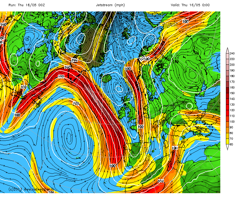
This, from the Netweather site shows how complex is the jet stream and winds in general at such heights.
This is from the Ventusky service. They do not show the Jetstream as such but selecting a level of 300hPa, you see the wind patterns around 10km (30,000ft) above the surface – around mid latitude jet stream levels.
Return to Home Page


