
About this page
Notes on whether to help those on Atlantic crossings whether going solo, on events such as those organised by the RAFSC or on the ARC.
Related page
On this page -
- Introduction to the Tropics
- Coriolis in the Tropics
- Tropical Depressions and Hurricanes
- Weather on Route
- Lagos to Cape Verde
- Cape Verde to Antigua
- The Caribbean
- Eastern Seaboard of the USA
- Florida to Delaware
- Delaware to Boston
- The Return
Introduction to the Tropics
This first section is a brief description of tropical weather where convection is the dominant factor. There are not the air mass differences and frontal systems that we see in mid latitudes. In broad terms, heating from the sun creates a low-pressure trough, virtually right around the globe. Inflows to this trough from north and south, deflected by the Coriolis effect, give the NE and SE Trade Winds. This Inter Tropical Convergence Zone is an area of much cloud and rain with light variable winds - usually known as the Doldrums.
Idealized View of General Circulation of the Atmosphere
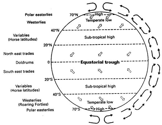
With the kind permission of the Editor of the MRNA Yachtsman's handbook
The diagram shows schematic cross section and surface winds on the global scale. Air going pole-wards from the sub-tropical highs meets air coming from the polar regions at the polar front. Air going equator-wards from the highs meets air of similar origins at the ITCZ. During the northern Summer the ITCZ moves north to about 14 deg N off the African coast and about 5 deg N over the Gulf of Mexico/Caribbean area. In January, it is still just north of the equator, about 5 deg N off Africa but south of the equator off Brazil.
Over the major continents of Africa and India, due to the greater heating of the ground compared to the oceans, the ITCZ gets further N to about 20N. The large low pressure areas over land associated with the ITCZ lead to the persistent and often strong SW winds of the monsoon, particularly over the Indian Ocean
What is the ITCZ?
''' When the sun moves northwards in the northern hemisphere Summer, the SE Trades cross the equator and turn to become SW due to the Coriolis effect.
In general, pressure within the tropics changes only slowly from day to day, but a diurnal cycle, a [[Atmospheric-Tides | Atmospheric Tide] will be very obvious with pressure maxima at around 1000 and 2200, minima at about 0400 and 1600 - all LT.
The range of pressure in this cycle is likely to be about 3-4 hPa. Be wary of any pressure change that bucks these trends.
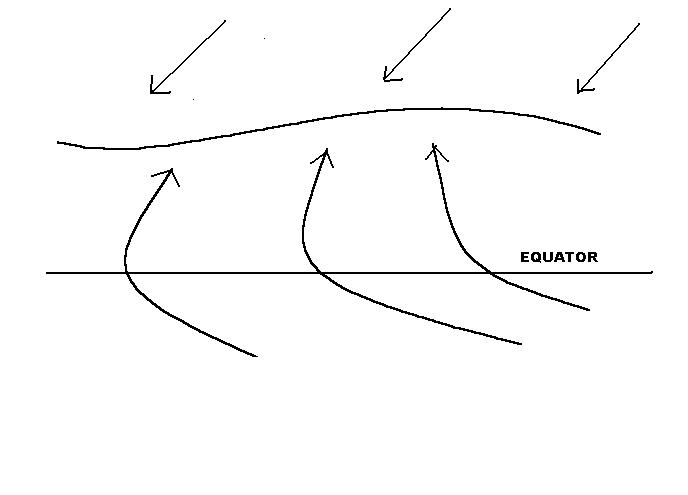
The NE Trades are characterized by generally fine weather with small cumulus clouds, scattered showers and moderate winds, often more E than NE to the south of the high, However, within, the Trades there are troughs of low pressure, known as Easterly Waves, moving E to W at around 10-15 kn. They give areas of heavier showers, perhaps with thunder. The wind will back ahead of them to NE and veer to SE behind. There is little warning of these waves which can occur at intervals of between 2 and 6 days or so.
Local heating over islands can often give showers, especially when the islands are mountainous eg Dominica which has frequent very heavy showers giving very dense forests and fast flowing rivers. Such showers drift downwind of their source.
An Easterly Wave
 .
.Areas of enhanced convection give enough upwards air movement to create an area of lower pressure. Air movement into these troughs form an nverted V-shape.
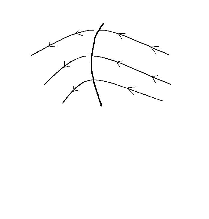
The Coriolis Effect in Low Latitudes
In mid-latitudes, most sailors will know that the strength of the wind depends upon the pressure gradient and that the Coriolis effect causes the wind to blow nearly along the isobars, but slightly across them towards low pressure. The closer the isobars, the stronger will be the wind. What some may not realize is that the relationship varies with latitude. For a given pressure gradient, the lower the latitude the stronger will be the wind for the same gradient. A pressure gradient that gives a wind of 20 kn at 50 deg N, will give winds of about 25 and 30 kn at 40 and 30 deg N respectively. However, in low latitudes the pressure gradient to wind relationship progressively breaks down as the air moves increasingly across the isobars. This is due to the weakening of the Coriolis effect. [For the mathematically inclined, the Coriolis effect is proportional to the sine of the latitude.] Right at the equator itself, the wind blows directly across the isobars. At or very near the equator, a low pressure will quickly fill up and a high collapse.
See may page How the Coriolis effect works.
Tropical Depressions
From May until December, tropical depressions must always be a possibility, although any in these two months are relatively unusual. June to November is the effective season with the peak activity in August, September and October. The trigger is often an easterly wave although it is rather more complicated than just that. If there is too much change of wind speed with height, then tropical depressions are unlikely. If winds diverge near the tropopause, then this increases the upwards movement of air in the easterly wave thus increasing the inflow of air at sea level and encouraging the formation of a circulation of winds because of the Coriolis effect. Sea temperatures are fairly critical. Large areas of around the size of the USA with temperatures >27 C are needed. This is one reason why the S Atlantic has never had a hurricane.
NOTE. In 2003, after I first wrote this page, there was a hurricane in the South Atlantic. It may be too facile to say that this was an effect of global warning, but it does imply that sea temperatures must have been higher over the South Atlantic than at any time in the past 1000 years or so for which there are accounts of ships crossing the oceans.
A further requirement is that there must be enough Coriolis effect for the winds flowing into the low pressure to form a spiral rather than just fill up the low. This means that Atlantic tropical depressions only form at about 10 deg or more north of the equator. Warnings are usually good and well in advance although they may not predict too well the most likely places to be worst affected until about 48 hours ahead. "Hurricane" is the name given to the severest form of tropical depression in the N Atlantic and Eastern Pacific. Such storms in the China Sea are known as Typhoons, in the Indian Ocean they are Tropical Cyclones. Meteorologically, they are one and the same thing.
Terminology used in bulletins and advisories is as follows
|
TERM |
Maximum Wind Force |
|
Tropical Depression |
Force 7 or less |
|
Tropical Storm |
Force 8 or 9 |
|
Severe Tropical Storm |
Force 10 or 11 |
|
Hurricane |
Force 12 or more |
Hurricanes are categorized according to their central pressure Category 1 to 5 with 5 being the deepest and most vigorous.
Early in the season tropical depressions seem to form anywhere between the coast of Africa and the Gulf of Mexico. Those that form near Africa usually do so before the end of September and often to the S or SE of Cape Verde Islands near an area of very warm sea. At this time of year the ITCZ is not far south of Cape Verde. Their tracks are W or WNW across the Atlantic. Once north of about 15 N they start to curve to the right (ie N and then NE). Those tracks usually take them to the west of the Azores, near or over the Caribbean Islands. Some tracks parallel the eastern sea board of the US, some cross the coast near Florida. Very rarely a hurricane will turn to the north near or even to the east of the Azores.
Later in the season, formation tends to be confined more to the Caribbean/Gulf of Mexico area. Sometimes they just wander around rather aimlessly but, more often, tracks are N towards Texas or NE toward Florida and the more western islands, such as Cuba, the Dominican Republic and Puerto Rico, then on to the Bahamas. Those that cross the coast into mainland USA usually weaken fairly quickly as they lose contact with their major energy source - the sea. Any hurricane near the coast or over land can spawn tornadoes.
Typical numbers of storms (ie tropical depressions with F 8 or more)
|
Type of Storm |
Minimum |
Average |
Maximum |
|
All Tropical Storms |
4 |
10 |
19 |
|
Those becoming Hurricane |
2 |
6 |
12 |
Seasonal distribution of North Atlantic Tropical Storms
|
May |
June |
July |
Aug |
Sep |
Oct |
Nov |
Dec |
|
0.1 |
<1 |
<1 |
2-3 |
3-4 |
2-3 |
<1 |
0.1 |
Over the past 200 years or so, in the months of January, February and March there have been one storm in each month. April is the only month in which there is no recorded tropical depression in the Atlantic.
In the Cape Hatteras, South Texas and Florida areas the probability of any specific location being within 100 miles of a tropical storm centre is about one year in three. Near New York it is about one year in five. Over the S tip of Florida, Cuba and the Bahamas the frequency is about one year in two or three, a little less over BVI, decreasing southwards to about one in five over Grenada and one in ten over the Venezuelan coast.
Near the eastern sea board of the US mainland during the hurricane season, it is best to be as far north as possible, probably north of New York at least. Tropical storms have been known to get as far north as Nova Scotia.
If in the Caribbean, then nowhere is really safe. Best advice is to be as far south as possible - perhaps Grenada in one of the deep bays on the south coast or in the Trinidad/Venezuela area. Pilot books advise against being in the Bahamas during the hurricane season. Some European insurance companies may refuse to insure yachts in the Caribbean during the hurricane season.
Perhaps slightly worrying is that climate changes now occurring could result in a lengthening of the season due to sea temperatures getting a little higher.
The Met Office numerical weather model is particularly good at predicting hurricane movements and has been used by the US Severe Storm Centre, Miami. For information on hurricanes and tropical storms, go to the Met Office Page or the NOAA tropical storm FAQ page.
Weather to be expected en route
Lagos to Canaries and the Cape Verde Islands
The Portuguese Trades resulting from the Azores high and the Spanish heat low give the prevailing northerly winds down much of the Iberian Atlantic coast. During October/November, fairly weak frontal low pressure systems move rather erratically between SW Portugal and Madeira, generally from the NW. Winds can therefore be rather variable although the predominant winds from Lagos to Madeira are likely to be between NW and NE mostly F 4-5. Any rain is mainly on cold fronts. Gales are fairly rare ~ 5% probability. South of 25 N gales are unusual. Because of the Portuguese Trade wind current, the sea will be rather cold and the air temperature, likewise, will be on the cool side.
Madeira, itself is near the northerly fringe of the NE Trades and the southern limit of the Portuguese N Trade winds. Note that wind statistics from Island stations are not representative of the open sea, eg Funchal, Madeira shows a predominant daytime S because of sea breezes and sheltering from the N.
Around the Canaries there are some very marked local effects that can give winds much stronger than over the open sea. Funnelling between Tenerife and Gran Canaria, the effects of the wind blowing slantwise onto the steep cliffs of the islands and funnelling down some valleys all may lead to winds up to 40 or 50 kn. Winter lows occasionally affect the Canaries, look out for pressure falls of about 10 hPa below normal.
From the Canaries southward, the winds are very firmly NE Trades, still relatively cool until about 20N, They then become hot, dry and dusty due to the Sahara - this is the Harmattan. Visibility can be quite poor in haze. With high pressure over about 1030 hPa the Harmattan can become very strong.
Approaching Cape Verde, the effects of the ITCZ may start to become evident. It should be quite well south by that time but it does meander somewhat. Easterly waves, associated with small disturbances on the ITCZ, can give very heavy showers, thunderstorms and, of course, strong gusts. A contributory factor is the very high sea temperature reaching about 29C just SE of Cape Verde. It is these troughs that may spawn hurricanes further to the west. Gusts can be enhanced by down-draughts to the lee of high ground and by valley funnelling.
Once away from Lagos, the currents should be S, increasingly SW, going driven by the prevailing winds.
Cape Verde to Antigua
The NE Trades near Cape Verde will become more E or ENE by about 35 W and be generally F 3-5. Chances of gales are just about zero, calms do occur with a probability of around 5-7%. Easterly waves are likely to give increased cloud, heavy showers and stronger, gusty winds from time to time. They are quite hard to detect from conventional observations although satellite pictures should show the increase in cloud. They are unlikely to be well forecast. Signs will be thickening cloud to the east, and perhaps lightning. There may not be much of a pressure fall ahead of a wave, indeed the pressure may rise just ahead of the first squall.
The Caribbean
Near the Leeward Islands in December, winds will be predominately E but with a fair number of NE and SE. Near the N and S tips of the islands, winds can increase by a force or so and become more pronounce NE or SE - whichever is the more adverse in my experience! Between the islands, the currents are also accelerated and deflected. So take care not to get taken down too much to leeward when on inter island passages, you could all too easily find it difficult to come up to wind against an adverse current.
Over the Caribbean, as a whole, from about Cuba southward, winds are generally around F 4-5 and hold up at night with few calms. Winds are more variable and generally lighter during August to October due to the proximity of the ITCZ although, paradoxically, this is also the time when easterly waves and tropical storms are most likely.
Otherwise, showers during December to February are relatively few except where they are formed by a combination of heating and orography. These showers can be heavy with gusts or squalls. Visibility is often good although it can be quite poor, especially when it is more windy than normal and, of course, if you are looking for a low lying island such as Barbuda.
For the rest of the year there are rather more showers, especially with Easterly waves which can occur at any time. Showers can then be particularly prolonged, heavy and frequent with very strong squalls. On the other hand, I have had a rare day in March when it was cloudy, rainy and windless for much of the day. Very rare.
Further north than Cuba, especially in Winter, extra-tropical lows with their frontal troughs can give strong to gale force winds with cloud and rain rather than showers. See the notes below regarding the US coast.
Eastern Seaboard of the USA
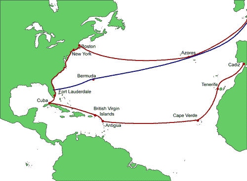
The Florida Current
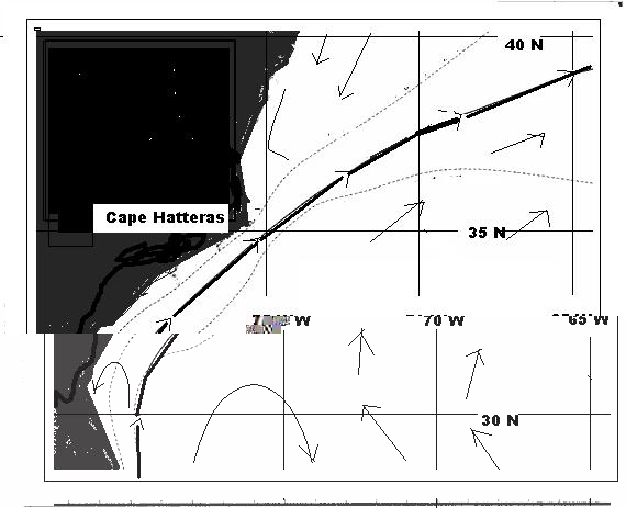
Typical position of the Florida current. Note the extreme positions of the North or West Wall. Note, also the eddies on both sides of the stream. Solid line - Florida Current/Gulf Stream Dotted line - North Wall extreme positions
An important feature is the Florida Current which becomes the Gulf Stream as it leaves the coast N of Washington DC. The N or W wall of the current can get very near the coast off Cape Hatteras and Fort Lauderdale and as near as 30 miles off near the Savannah River.
Florida to Delaware
From Fort Lauderdale to the Savannah River, the climate in the far S is typically tropical maritime, much as the Caribbean but there is a steady transition to a continental type to the N of Florida. The Azores high is a dominant feature and, in the Winter, the North American Winter high also. In the Winter occasional extra tropical (mid latitude) depressions can make their presence felt as far south as the Gulf of Mexico.
From the Savannah River northwards is a breeding ground for frontal depressions, particularly in the Winter months. It is then that lows forming over the Gulf of Mexico, migrate northwards. These often deepen rapidly in this area to become the infamous Cape Hatteras lows.
When the wind is blowing across the N wall of the Florida current from the W or NW, there is an increase in turbulence and wind speed. This effect is very limited and will disappear a few miles towards either colder or warmer water. In the south, sea breezes can be strong and the whole stretch of coast is generally rather windy. Tropical storms are always a possibility in the season.
Probability (%) of winds > F 5
|
Area |
F5 + in Winter |
F5 + in Summer |
|
Off the Florida Coast |
45 |
25 |
|
East of Cape Hatteras |
50 |
12 |
|
Off Chesapeake Bay |
45 |
22 |
|
Off Delaware Bay |
55 |
12 |
In the south, rainfall is likely to be convective or associated with Tropical storms. Further N, frontal rain is common. The N wall of the Florida current is frequently cloudy with low stratus. From about Cape Hatteras northwards, sea fog is likely in the Spring/early Summer whenever warm air is crossing the Florida current/Gulf Stream (from a S or SE point).
Sea Temperatures off the Eastern Seaboard of the USA
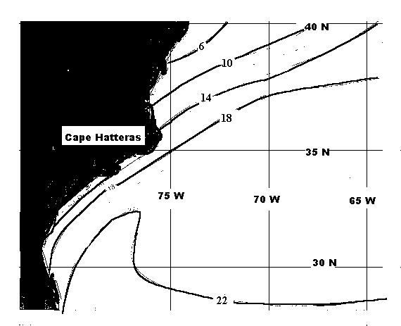
Isotherms in February. Note the strong gradient off the Cape Hatteras area.
The diagram shows the very strong gradient of sea temperature of the coast of the US. This is one of the factors that influences the development of depressions
Delaware to Boston
Mobile, frontal lows are common, especially during the Winter from November to March when lows are likely every two or three days. Winter gales, rain and sea fog are frequent. Gales occur with about 30% probability about 150 - 200 miles off shore. The Summer half of the year is quieter with fine spells and periods of low pressure, much like the UK. To the N, the effect of the Labrador current is to give a high probability of sea fog banks.
Gales off the US Coast
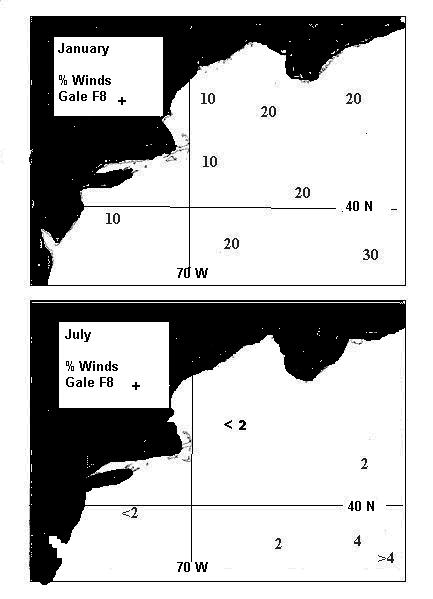
Frequency of gales, Force 8 and above off the coast of North America. Note the very high values in the Winter. These are due to the large number of depressions forming to the southwest, particularly the Cape Hatteras Lows.
The return trip
The lows forming off the Eastern seaboard of the US can either move across the Atlantic or create breakaway waves that have the same effect. Either way, it can be quite disturbed between the US Coast right across the Atlantic. During 2000, for example, the Azores high collapsed and sank a long way south for several weeks in late May/June. Anyone crossing the Atlantic direct to the UK or via the Azores would have had a rough passage.
The optimum time for the return trip, whether direct or via the Azores is probably to leave the US or Bermuda in sufficient time to get to the Azores before any early season hurricanes have a chance to turn northwards to the east of the Caribbean but late enough to avoid the worst of the Winter Atlantic depressions. This will mean dodging east coast depressions to get from the US to Bermuda, perhaps around mid to late May, so as to be on passage from the Azores to the UK or to Lagos during June/July. To minimize the chance of gales, keep south of 40N for as long as possible. Remember that August is a month when very severe Atlantic depressions can occur - eg the Fastnet Storm. High sea temperatures, very moist air and copious quantities of latent heat are important here as they are in hurricane formation.
Anyone wanting to return to the Caribbean after the hurricane season could have some difficult decisions with the predominantly E to ENE winds and an adverse current. Leaving from a little S of Cape Hatteras could give a reasonably free wind until near the Bahamas. Thereafter, it is likely to be a close fetch with an adverse current. In the Atlantic Pilot, Anne Hammick advises against crossing the Florida current in a vessel that cannot make 10 kn!