
About this page
How wind affects the sea; can it be predicted and should sea state be included in forecasts?
On this page -
Summary
There are requests from time to time for more detailed forecasts of sea conditions. I have been asked why the UK does not include swell height in its marine forecasts.
Here, I try to explain how waves and swell are formed and why sea state can be so variable in space and time.
Sea state depends on wind, current, coastal topography, the depth and nature of the sea bed. A sailor should be able to predict, qualitatively, how rough the sea is likely to be using a local wind forecast, tidal atlas and charted warnings of overfills and eddies. As in all of sailing, predictions will improve with experience gained and lessons learned. It is my belief that sea state near the coast cannot usefully be predicted on the space/time scales of an inshore waters or offshore forecast.
Swell originates beyond the areas of local forecasts and varies depending on its source, so it is hard for a sailor to predict. It can be a hazard at some harbour entrances and, in those cases, swell forecasts for the coasts affected are valuable.
The Theory
Wind waves
When the wind starts to blow over smooth water there are small frictional effects. These create, first, cat's paws and, then, ripples on the water. As the wind increases, the ripples get larger until they soon become large enough to be pushed along by the wind. However, the movement of these wavelets is slower than the wind and the pushing of the wind on them causes an increase in size until they become steep enough to break. Typically, this starts to happen when the wind is about force 3 on the Beaufort scale.
Increasing wind strength increases the wave size and the number of breaking waves increases simply because of the wind making steeper and steeper waves that are too high for their wavelength.
As the wind increases further, there are several quite well defined phases, for example when spray starts to occur and when foam is created. These stages are well described in the internationally accepted Beaufort scale definitions.
Swell
Wind waves are a local manifestation of the energy that has been transferred to the sea from the wind. This energy travels downwind away from the source area, rather like ripples in a pond when a stone is dropped in, or from the bow wave from a ship. These waves that move away from their source are known as swell. The stronger the winds at the source area, the bigger will be the swell and the further will it travel. The longer that the wind blows in the source area, the longer will the swell persist, even long after the wind has ceased or changed direction.
As these waves move away from the source area, energy is transferred from the short wavelength, high frequency waves to longer and longer, lower frequency waves. This cascading energy effect will be recognised by those with a background in physics. Thus, the wavelength of swell increases with distance away from the source but the height, or amplitude, decreases relatively slowly.
Because of their length in relation to their height, swell waves do not break even if the wind is still blowing over the swell. The wind may cause wind waves superimposed on the swell but, often, the wind will have died away or changed direction so that wind waves may well be across the swell. A swell coming from a different direction to the waves and swell generated by the local wind may indicate that a front is approaching. The wind waves will have been caused by the local wind ahead of the front, while the swell is being caused by the wind behind the front.
Trains of swell waves can arrive from more than one direction. Experienced officers of the watch on the bridge of a ship can often report swells from two or even three directions, of differing periods and amplitudes.
The very large amounts of energy transferred to the sea results in swell waves being fast moving and extending far deeper than the waves produced locally by the wind. Many of us are familiar with the long rolling swells that come in from the Atlantic. They are particularly evident around western coasts of the British Isles, France and Spain.
Swell can travel enormous distances. Strong winds down the east coast of South America can create swell that reaches Nigeria. By that time the swell wavelength is so long that wave crests cannot be detected. However, large, slow sea level rises and falls occur as the very flat waves arrive.
Refraction and reflection
Rather like light and sound waves, water waves can be subject to refraction. The most obvious example is when, on the beach, we see waves approaching the beach nearly parallel to the shore when the wind creating the waves is along the coast. The waves nearer the shore in shallow water travel slower than those further out in deeper water. The result is a rotation of the wave train. The effect is rather like a line of soldiers given the command to "Wheel Left". Those nearest the left hand of the line take short steps and, therefore, march slower than those further out who take longer steps. The result is that the whole line changes direction.
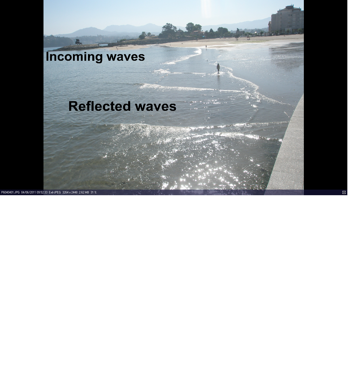
Reflection occurs when waves meet a solid barrier such as a harbour wall. Not all the energy is dissipated when the waves hit the wall. Some remains to bounce back and create a very confused sea. I saw this once when entering Dover harbour in a not very seaworthy motor boat in a force 6 wind. Very unpleasant.
The picture here, taken in Bayona, shows a line of waves coming in from left to right. At the bottom, waves are reflecting off the wall and crossing the incoming waves. Of course, this is a mini example but the same happens on large scales and can create very rough and disturbed seas.
The Reality
Over the open sea
The first complication is that swell and wind waves, being caused by winds of varying strength are of varying sizes travelling at different speeds. Faster moving waves catch up smaller, slower ones and either combine to produce larger waves or cancel each other out. There are statistics that give some support to the old rule of thumb about every seventh wave being a big one.
The second complication is that wind waves are often superimposed on swell. The combination can be critically important to cargo vessels. Certain directions of swell or waves and size of total sea can cause deck cargo to be washed overboard or grain to be shifted dangerously. A ship in ballast in a big sea can suffer damage due to pounding. For a yacht, such effects can make handling difficult and dangerous.
Coastal and sea bottom effects
The larger the wave, the deeper down will the wave action occur. As waves move from deep water to shallower the depth of the sea bed starts to restrict the wave action. The waves slow down so that the energy of movement (kinetic energy) is reduced. The energy released causes a steeper sea ie higher waves relative to the wavelength. A marked increase in roughness and much breaking of waves is likely to occur. Similarly, with waves running into a narrower stretch of water.
Where there is a very marked change in water depth or where there is a very uneven sea bottom then, with some tidal states, overfills and whirlpools can occur. Such areas are marked on navigation charts, Obviously, they should be treated with extreme care and respect. Near headlands, such as Start Point or through narrows such as the Needles Channel, wave energy over a wide front is forced to go through a narrower one. Coupled with a shallowing of the water, the result can be some very rough and unpleasant conditions.
Tidal stream or current
"Wind against tide" is a well-known phrase and one dreaded by many small boat skippers. There are various ways to view the physics of this phenomenon. The scientifically correct way is to look at the movement of the water particles within the wave. Perhaps an easier, more intuitive, way is to realise that a stream or current going in the same direction as the wave train will increase the wavelength relative to the height of the waves. The effect will be a smoother sea.
If there is a stream in the opposite direction to the waves, then the wavelength will be decreased relative to the wave height. The waves will become steeper and they will start to break.
Perhaps, more correctly, it is a question of wave direction with or against the tidal stream or current.
The three effects of tidal stream, coastal topography and sea bottom can come together. Such well known danger areas as the Raz de Sein, the Alderney Race, the Swinge, Start Point and Portland Bill are well known to British sailors as places to be avoided in wind against tide conditions. The combination of very strong tidal current and rough water can render a small vessel dangerously unmanageable.
Bays and coves
Anyone who has spent the night in even a gentle swell will know how unsettling it can be. That nicely sheltered bay seemed fine when you dropped the anchor in a gentle wind. You knew that it would drop at night but you forgot the swell.
A little swell that might have been formed some distance away can become very obvious when the local wind has gone and the boat swings across the swell. What is so surprising sometimes is how it can come around headlands due to refraction. If the bay is small, then reflection off the sides can become all too obvious as well.
We have found this to be a particular problem in the Mediterranean around the Balearics. Here there are many delightful small coves seemingly well sheltered from wind and swell. But, the Mediterranean is a sea very prone to a confused swell. This is probably due to two factors. First there is the geography with many coast lines and islands. Secondly, there are the various wind regimes.
A swell running along one coast of Mallorca can bend right around the corner and affect the adjacent coast in a most surprising manner. "Another of Frank's rolly anchorages," is a cri de coeur heard more than once!
Can Sea State be predicted from Numerical Weather Models?
The answer is YES - in principle, at least. The energy transferred to the sea from the wind can be calculated from a knowledge of the basic physics involved. Away from the coast there is no real problem, given a good wind forecast. Wind waves and swell can both be calculated straight from the output of NWP models. Knowledge of large scale sea bed topography and tidal streams can be taken into account in the mathematical calculations and swell predictions are generally good. The practical problems are close to the shore where small vessels are likely to be and where they can be severely affected by rough sea in places such as those mentioned earlier.
In practice there are several problems
- It is not possible to predict winds on the scale of small features on the sea bed. Due to problems of predictability.
- Tidal streams are continually changing in space and time.
- Effects of headlands and other coastal features can also be very variable spatially.
For forecasts such as those broadcast by HMCG around British coasts, all that can be done is to say the obvious. In other words, to assume that a wind of Force 4, 5, 6 or whatever, will give a sea state as described in the Beaufort Scale definitions.
And, need it be?
Should sea state be included in forecasts? Strictly speaking, the answer must be YES; this is an IMO requirement.
Are sea state forecasts necessary? Bearing in mind the problems in being specific and the ability of sailors to use experience to interpret forecast of wind in conjunction with well known tidal streams, the answer is probably not. My personal experience has been that forecasts of sea state are often meaningless except as a confirmation of what wind force is being predicted!
The thinking sailor should be able to use his experience and intelligence to decide how bad the sea might be in his area and on his route. Pilots, almanacs and Sailing Directions should be carefully studied. Going through the Raz de Sein, for example, should only be done after careful consideration of the wind force and direction and the tidal stream at the expected time of passage.
The EXCEPTION must be for swell. Because it can be formed far away, the sailor has no option but to rely upon computer predictions. These are comparatively easy over the open sea and can give good advice for swells approaching a coast, particularly when the water is deep until close inshore.
Around some coasts, swell is a major determinant of whether it is possible or prudent to try to enter or leave a port. Notable examples in my sailing experience are ports down the west coast of France and around Biscay or Atlantic coasts of Spain and Portugal.
The entrances to some French ports such as Sables d'Olonne and St Gilles Croix de la Vie can be impossible in a big swell. Similarly, the Gironde estuary channel leading to Royan, and the entrance to Arcachon, can become highly dangerous. CROSS issues warnings along this coast and it is always prudent to keep a listening watch. If in any doubt. give them a call on VHF. They would far rather give you advice than have to mount a rescue operation! If going to Arcachon, it is advisable to telephone the semaphore station at Cap Ferret. They will give a window of opportunity up to about 24 hours ahead and will refine that advice when you are approaching the area and call them on VHF.
Similarly, ports such as Zauraz and Ribadesella along the north coast of Spain and several ports on the Atlantic coast of Portugal are either just impossible or best avoided when there is a big swell running.
My personal view is that Inshore waters forecasts should include swell wherever or whenever this is a cause of concern to vessels entering harbours along that coast. Around France, CROSS often say, simply, "houle non-significatif" but give a value when it might be a hazard.
When it comes to shipping forecasts on BBC LW or NAVTEX then it is, partly, a question of time available, the number of words used and the need for brevity. For forecasts on such time and space scales the user can look at the Beaufort descriptions and know instantly what the wind-sea state is likely to be. I would argue that to include wind generated sea state amounts to tautology. Swell height forecasts would be useful on occasions around the UK; whether enough to justify a longer forecast is a matter of some doubt to my mind.
Other Effects of Wind on the Sea
Lake and Lagoon Oscillations
When winds blow across water, the frictional drag causes water to be pushed across the area over which the wind is blowing. This can be seen on many scales. For example, in Northern Ireland, a steady wind across Lough Neagh can cause significantly higher water levels on the leeward coast. On the large scale this happens across the North Atlantic and is one of the causal factors for North Sea tidal surges (see the next section).
When the winds stop blowing or cannot sustain the build-up on the lee shore the water tries to return to its normal level. The momentum of the moving water can causes an overshooting effect and the water piles up on what was the windward side. The same process then occurs in the opposite direction with a similar overshoot. And so on, with decreasing amplitude.
This slopping about of water is rather like what happens when you tip a saucer to and fro. Galileo realised that it happening in the Mediterranean as a whole and that it supported his ideas about the earth rotating on its axis and orbiting around the sun.
This oscillating effect occurs in lagoons in the north of the Adriatic but, here, water escapes slowly through the entrance to the lagoon. This has a dampening effect on the process. In August 2005, we observed this happening on a smaller scale at Pomer at the extreme south of Istria. The bay is only about 2 NM wide at most but there is a narrow entrance. There was a period of several hours with strong southerly winds that must have driven the water into the bay. When the wind dropped, the sea level at the marina fell and then rose a total of about 3/4 of a metre every 20 minutes or so. Gradually, over three hours the oscillation got less and less.
On the scale of a large lagoon such as those of Venice, Marano and Grado the time scale of the oscillations will be several hours and the height change not as much as in the rather magnified Pomer case.
Tidal Surges
These are best known to British sailors because of the devastating 1953 floods that affected many places on the East Coast and in the Thames Estuary. Surges are not infrequent but those of similar severity are thankfully rare and result from a fairly specific concatenation of events.
There are four contributory factors that are critical for dangerous East Coast tidal surges -:
- A high astronomic tide.
- Strong SW winds across the Atlantic to the south of a fast moving low.
- That low deepening and passing to the North of Scotland around the time of high water, and.
- Strong NW winds, behind the low, developing down the East Coast while the high water peak moves southwards.
The strong SW winds "pile up" the water on the eastern side of the Atlantic to give an even higher tide than predicted in tide tables. The low pressure to the north of Scotland lets the tide rise further - see another page for a description of this effect.
The strong NW winds down the East Coast help the tidal surge to become even higher. A NW direction is the optimum because that drives the water south-eastwards parallel to the coast but the Coriolis effect on the water causes it to turn to the right ie towards the coast. A due N or a NE wind has a lesser affect. The shallowing water and the narrowing of the distance between the British and mainland Continental coasts help to make the tide higher and higher relative to the tide table heights the further south the tide comes.
The 1953 flood had all these effects at just about their most critical. Tidal surges occur in other areas, for example, around SW England and the Bristol Channel. But, here there are never quite all these factors working to such effect. Nevertheless, increasing sea levels that are expected with global warming might make such events less rare.
Following 1953, there has been a Storm Tide Warning Service, operated jointly by the Met Office and the Hydrographic Office, funded by the Environment Agency. When dangerously high tides are forecast, events are monitored using tide gauges right round from the north of Scotland and down the east coast of Britain. This enables predictions to be updated as the surge moves southwards.
And negative ones
Because wind exerts a drag effect on water. a strong wind, can reduce sea levels as well as increase them. This can be important when large tankers are coming through the Dover Strait into the North Sea. In some conditions, they can touch bottom.
Strictly speaking, the term "negative surge" is a misnomer. Unlike a tidal surge there is not the progressive effect. "Negative surges" just seem to occur in situ as a result of the wind and pressure in the general locality,
Like tidal surges these conditions can be predicted from the meteorological factors of wind stress on the water and the the effects of air pressure pressing down on the sea. The sailor can calculate this effects of pressure himself - an imcrease/decrease in air pressure of 1 hPa will cause a decrease/increase in sea level of 1 cm.
Warnings of these so-called negative surges are issued to the Environment Agency to help protect the sea from oil spills and other marine accidents, There could be a case for these warnings to be more widely distributed within the general context of Marine Safety Information for small vessels crossing river bars or when crossing sills into a tidal basin. Whether these are sufficiently common or dangerous to small craft is debatable.
And Tsunamis?
Despite the media using the term "Tidal Wave", these are not tidal phenomena in any way. As most people are aware after the Boxing Day 2004 Indonesian Tsunami, these are caused by movements of, or eruptions on, the sea bed. The power of these waves, the devastation and destruction caused are awe inspiring. The Tsunami is a very extreme demonstration of what is, initially, a very small wave, moving very fast and therefore with much energy. When it reaches rapidly shallowing water much of the energy of movement is converted into making the wave extremely high. This is an extreme example of swell approaching a shore line.
As well described by eye witnesses the first sign is a withdrawal of water from the coast to unprecedented distances. The wave then comes, rapidly growing in size as it enters shallowing water. Out at sea it may have been barely noticeable. After withdrawing again, the sea returns and this cycle is repeated several times. Another, highly magnified example of the "slopping about" effect described earlier.
Less well publicised Tsunamis occur in the Mediterranean. One notable occurrence was in May 2003. This caused great damage but, fortunately, no loss of life, in Mah¾n, Menorca. In Cala Taulera, at the entrance to Mah¾n, it was described as "a sudden rush of water out of the harbour at very high speed dropping water levels by up to 3 metres, this caused many boats to drag or dislodge anchors and be swept against each other causing mostly collision and rigging damage. One very large boat (23 metres) sheared its windlass shaft. Surprisingly, it appears that the return of the water may not have been as bad as the out flow"
At the same time, CA members, Bill and Rona Musker were in Torrevieja on the east coast of mainland Spain. Bill said (Rona slept through it all!) that, "The water level rose and fell by 2 metres over a 15 ¢ 20-minute period. This continued for three hours and caused damage to boats with bowsprits and anchors overhanging the quays."
The Pilot book for Islas Balķares, refers to rapid oscillations in sea levels of about 1 m that occur in some harbours on Mallorca and Menorca. It suggests that these are due to certain weather patterns. The events of the Mah¾n Tsunami and Bill Musker's description at Torrevieja does raise the question as to whether the meteorological reason for the effect is correct. Earthquakes, under the sea are not uncommon in the Mediterranean. In the absence of any hard meteorological evidence to the contrary, I suspect that some, at least, of these tidal oscillations in the Balķares are a Tsunami type rather than a meteorological phenomenon..