
About this page
An explanation of the sea breeze, a complex feature that affects us all.
Preamble
A Yachtmaster instructor friend once told me that he thought that the RYA gave too much attention to the sea breeze in its course syllabus. A strange remark because most of us sail, for preference, in the Summer months and near the coast. I suspect that he was really thinking of the �classical� sea breeze described, usually incorrectly, in geography text books and yachting magazines. Here I want to broaden the concept of the sea breeze mechanism and give some ideas on what to look out for and what to expect.
Related pages
- How pressure differences are formed
- The Coriolis effect
- How the sun's heat gets into the atmosphere
- Does the wind veer as it crosses the coast and why, or why not? Other coastal effects
- Why does the wind not always veer in a gust as the books say? see NOTE
- Latent Heat
On this page -
- The theory of the sea breeze
- Why it Veers
- Effects of topography
- Times of year
- Some examples in Spain
- And elsewhere
A Little Theory
Sea breezes, like all winds are caused by pressure differences � pressure gradients. These arise from the way in which the air is heated and cooled. This is true for winds on all scales from the global, monsoon, scale right down to what happens around Island Barn reservoir at Walton-on-Thames. In a nutshell, warming the ground causes warming of the air above it and that leads to a decrease in the pressure at ground or sea level.
On the large scale, this is the cause of Monsoons, Trade Winds, jet streams and the low that sits over Spain for much of the Summer half of the year. Conversely, cooling of the air leads to high pressure. See my page on how pressure differences are formed.
The Winter Siberian high is one example; the cooler water in mid-Atlantic compared to further south leading to the Azores high is another.
Of course, the atmosphere is far more complicated than the simple concept of highs in cold areas and lows in warm ones. Pressure differences create air movement as gravity takes effect and air tries to move from high to low pressure. As we are well aware, the earth is spinning and the Coriolis effect causes air to be deflected to the right (in the northern hemisphere.) Buys-Ballot told us that pressure is lower to the left when standing back to the wind.
A schematic Sea Breeze
These diagrams show how the sea breeze forms and how the sea breeze front creates convection. NOTE - The sea breeze is NOT caused by convection over the land. The convective cloud is a result of the sea breeze dynamics.
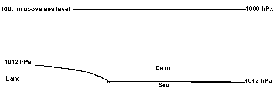
At dawn, pressure is uniform over a wide area. At a height of, around 100 m, the pressure will also be uniform.
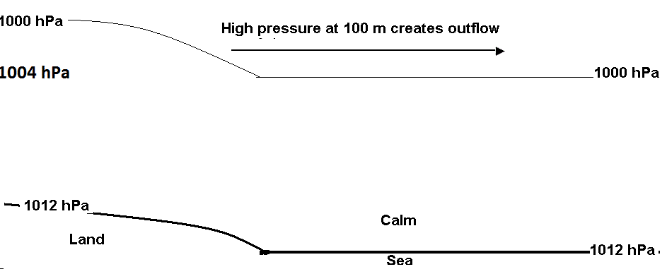
The sun heats the ground which then heats the lowest levels of the air. The air expands. Above the 100 m level there is now a greater mass of air exerting a greater pressure
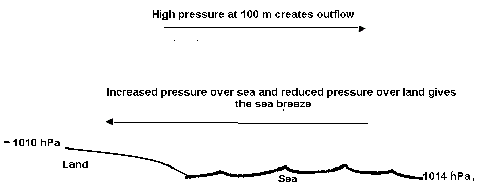
The pressure gradient created at 100 m leads to a flow of air at that level from land to sea. This reduces the weight of air above the land and increases the weight of air over the sea. The result is a flow of air at sea level from sea to land. Continued heating of the land keeps the sea breeze going and spreading further and further inland.
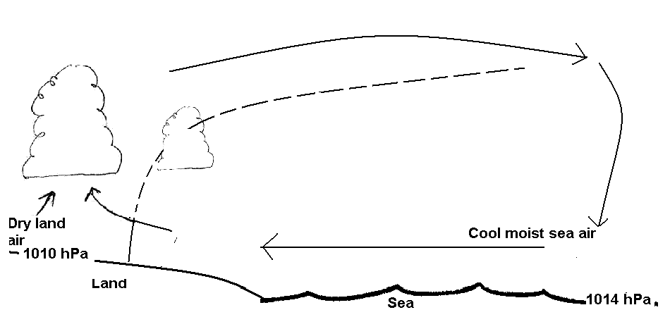
The air coming off the sea is cooler and moister than the air over the land. This difference is often referred to as a "sea breeze front". The ascent of air at this front creates a line of cumulus cloud. This moves inland during the day.
Veering Sea Breezes and the �Vent Solaire�
With a fairly low lying coast, the sea breeze usually sets in straight onto the coast. Shortly after setting in, it then veers (due to Coriolis) over a period of a couple of hours or so. We had a very marked example of this along the east coast of Italy between Vieste and Brindisi, see below.
The �Vent Solaire� is a daily cycle of sea breeze and land breeze. A good example occurs between the Vilaine river in Southern Brittany and the isles of Houat and Ho�dic. In settled weather with a high pressure area to the north, the night wind is off the land. During the morning, heating of the land starts up the sea breeze more or less in an opposite direction to the night time land breeze. This causes a weakening of the offshore wind. Maybe a reversal.
(NOTE. The name Vent Solaire used by many sailors is, in fact, a misnomer. It is the French term for the solar wind � a stream of particles in the stratosphere.)
The sea breeze then becomes northwest and strengthens. But, as the land cools in the late afternoon and evening the sea breeze effect weakens and the wind reverts to the northwest around the high to the north. During the night the cooling land and the channelling effect of the Vilaine valley funnel the offshore wind and increases it to a good force 4 or so. See below.
Someone deterred by the sea breeze from anchoring to the west of Houat might seek shelter on the eastern side only to have a disturbed night in the land breeze. The western side would have been better after the sea breeze died away!
When formed by a low lying coast, a sea breeze is likely to veer.
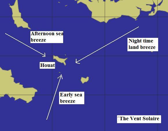
A night time wind can be weakened ore even reversed by the sea breeze. In the �Vent Solaire�. the sea breeze first veers then, in the late afternoon dies away. The offshore wind strengthens due to the land breeze effect.
Topographic effects
A very well known example of the sea breeze being affected by topography is around the Isle of Wight. Here the sea breeze can set in on to the mainland shore driven largely by the heating of Southampton and surrounding towns. Because the sea breeze does not easily flow over the Isle, it will be deflected around the island and flow up the Solent from both ends. This gives the well-known curiosity of two yachts running under spinnaker towards each other somewhere off Cowes, only to start beating as they pass each other. See below.
Along the Devon coast my experience is that the sea breeze will set readily into Plymouth Sound and Tor Bay where the built-up areas heat up quickly. The sea breeze will occur but less readily into Bigbury Bay and Start Bay with their fairly low coast lines but little built up areas.
The sea breeze will not blow directly onto the steep cliffs between Bolt Head and Bolt Tail, between Dartmouth and Berry Head nor onto the Babbacombe heights to the north of Torbay. However, the strong heating of Torquay and Paignton pulls air from around Berry Head and, from the opposite direction, past Babbacombe. Returning to the Dart from Tor Bay can be a stiff beat in such conditions.
The figure below shows this effect that, again, is clearly shown when two yachts approach each other from opposite directions across Tor Bay. Somewhere towards the north side, nearer to the Ore Stone than to Berry Head, they drop spinnakers, start motoring before beating in opposite directions. The same can happen off Plymouth Sound where a yacht running past the Yealm and the Great Mew Stone will meet one running from the direction of Rame Head.
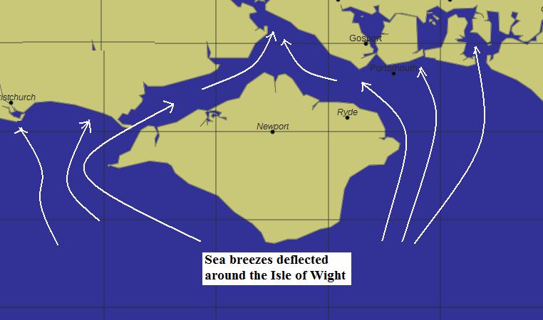
The sea breeze can only flow around the Isle of Wight.
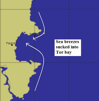
Schematic of sea breeze being sucked into Tor Bay around the cliffs of Babbacombe and Berry Head. Between the Dart entrance and Berry Head the sea breeze can easily reach force 4 or 5.
When does it occur and how far out?
The NW European sea breeze season is generally agreed to be from late Spring until late Autumn, but the best sea breezes will be when there is the biggest difference between sea temperatures and those over land - probably June and July. On those all too rare, sunny, Summer days, the sea breeze is very regular and used to be reputed to reach Itchenor clubhouse (Chichestor harbour) at opening time!
Careful study of wind observations do, in fact, show that the sea breeze can be detected, albeit very light, even in December and January at favoured locations.
How far out to sea the sea breeze extends depends on the amount of heating. I have found the effect up to 12 or 15 miles off the coast in the Torbay area. On very hot days, the sea breeze can extend as far as mid Channel. Down the Red Sea, we used to see the effect on observations from ships at about 100 miles out. Very detailed analysis of wind patterns has shown that, on hot days, the air in mid Channel flows toward France in the south and towards England in the north.
A very good picture of this effect can be seen on another page of this site. The separation between the two flows is an area of very light winds. Alan Watts calls this Channel Starvation.
Some Spanish oddities!
We found an example of Channel Starvation off the south coast of Spain. On apparently good sea breeze days it was either non-existent or very feeble. As this is a low lying coast with south facing hills a little way inland, this was surprising as it had all the appearances of a good sea breeze coast.
I put this down to the relatively near coast of north Africa and suspect that the African sea breeze sucks air away from the Costa del Sol and prevents marked sea breezes on that coast. A similar effect occurs on the south coast of Jersey where the sea breeze forms but is then reversed by the sea breeze into the Bay of St Malo. The mechanism was probably like that mentioned earlier. Off the Costa del Sol, this separation must have been very near the Spanish coast.
Along the east coast of Spain, almost regardless of the morning wind, the sea breeze seems to set in rather late in the day, typically after about 1600 or 1700 local time. However, in terms of "God's" time (i.e. UTC) this is only about 1400 or 1500 hours, 2 or 3 hours after solar noon. This may still seem late by UK standards, but the sea is very warm and the land has to get hot to create the required pressure gradient.
Sometimes the Spanish east coast sea breeze lasted for two or three hours and reached a good F 6 or even 7. The effect of significant headlands, such as Cabo San Antonio, can be quite important in strengthening the breeze locally. At other times it died out fairly quickly and only just got to a F 4.
It is not immediately obvious why this should occur, but if the pressure is high then the air will have been subsiding and this can kill or weaken the sea breeze. Alan Watts has suggested that a clue can be had by looking at the western horizon around sunset. Subsidence causes a temperature inversion ie a lid that inhibits convection and the sea breeze. This can be evidenced by a light blue strip caused by dust and pollution trapped at the inversion. This takes very good and careful observation - beyond my abilities!
And elsewhere - some random notes
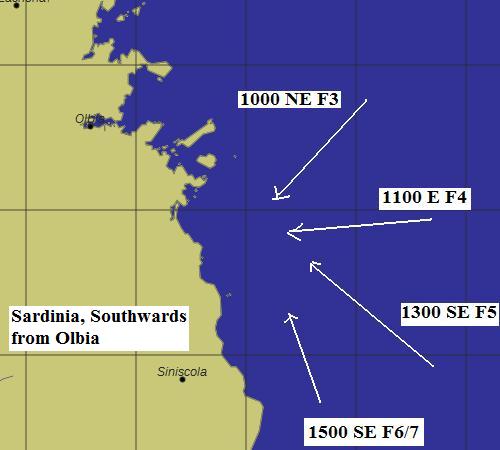
- Around the east of Sardinia, we found some very strong sea breeze effects. despite Italian forecasts of Force 4 or 5, we had winds of up to Force 7 in the late afternoon just when we were wanting to enter a harbour exposed to the south - the sea breeze direction!
- To the east of Levkas Island, the island sea breeze can be sufficiently strong on the eastern side to counter the prevailing NW winds.
- Down the east coast of Italy, see above, the sea breeze seemed to be a very regular occurrence.
- To the south of the Messina Strait, between Italy and Sicily, there can be a southerly on the Sicilian side and a northerly on the Italian side of the Toe of Italy. The transition can be quite sharp.
- A very large scale sea breeze effect helps to maintain the strong northerly winds to the east of Iberia - the Portuguese Trades.
- Down the coast of Croatia, the large scale night time katabatic gives predominately NE winds at night but the warming of the land gives a NW wind during the day. This can be seen in GRIB code output.
See also
Return to Home Page