
About this page
This basic question lies at the heart of all our weather from global winds down to the smallest local effects.
Related pages
The start
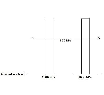
Stage 1
Start with a flat calm. Pressure will be uniform over a large area, say 1000 hPa. At some height AA above the surface, pressures will also be uniform. For sake of simplicity, I have put 800 hPa.
Warming up
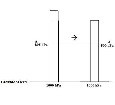
Stage 2
Now, let us warm the ground under the left hand column. The warming, initially, will be greater near the ground. The air here will become less dense; that is, it will occupy a greater volume. The column as a whole will expand.
The result is that there is now a greater amount of air above level AA. There has been no change of surface pressure. However, the greater pressure above level A in the left hand column has created a pressure gradient at that level as shown by the arrow. Air will move in that direction.
The first low level movement
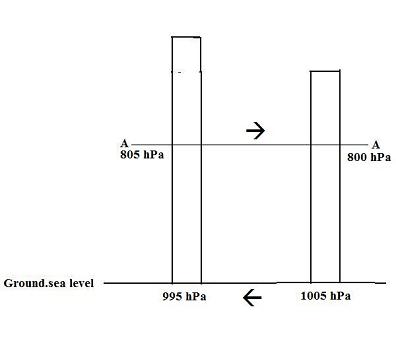
Stage 3
The result is to remove air from the left hand column and transfer it to the right hand. A greater weight of air over the right hand column and a reduction in amount of air in the left hand column creates a pressure gradient at the surface. The movement of air at the surface is shown by the lower arrow.
Discussion
This is a highly idealised description of how pressure differences occur in our atmosphere. The numbers are unrealistic but the principles are sound.
In the case of a sea breeze, the heating of the air will be in the lowest layer near the ground; perhaps the lowest 100 to 300 metres. On the large scale such as the Trade Wind circulation and the formation of Jet Streams, the heating from the earth will be right through the atmosphere. First, this is by convection which can carry heat right up to the tropopause and lead to warming by latent heat effects. Secondly, there is radiation with heat from the earth being absorbed by gases such as water vapour, carbon dioxide and methane.