
About this page
Changes in wind due to coastal effects. Does it veer or back as it crosses a coast?
Preamble
The behaviour of wind around the coast is often not well understood. It is very easy to try to apply simple "obvious" logic to meteorology and finish up with misleading answers that can be seen in well regarded text books, including those sponsored by the RYA.
Mike Brettle, who used to work in the UK Met Office Boundary Layer branch and who is also a sailor, has challenged some of the accepted wisdom regarding coastal effects on the wind. The first part of this page is a result of his deliberations that might make unexpected wind behaviour more understandable. The second part goes on to remind sailors of the effects of headlands and other coastal features on the wind. Heating and cooling effects are discussed on my Sea breeze page.
Mike also takes issue with the theories regarding gusts and whether they veer or not.
Related pages
On this page -
Accepted Wisdom
The following are direct quotes from well-known yachtsmen, coaches or advisors.
|
David Houghton and Fiona Campbell: |
....the wind must veer as it moves out over the water. ('Wind Strategy' third edition) |
|
Jim Saltonstall: |
..the wind tries to leave the shore at right angles.. (RYA Manual of Race Training) |
|
Stuart Walker: |
It is sometimes suggested....a sailor should expect a progressive back with approach to shore. Such a progression is rarely evident except in stable offshore flows.. ('The Sailor's wind') |
|
Chris Tibbs: |
When the wind blows off the land it will increase and veer. ('RYA Weather Handbook') |
What does this tell us? Since some of these views are contradictory one implication is that at least some leading sailing experts are wrong in their understanding of wind at coastlines. Another conclusion is that winds at coastlines are very important for yachtsmen, even if they can succeed at the highest level with some serious misconceptions.
The theory of how wind is likely to respond to passing the coastline is quite subtle. However, meteorology is an observational science and over the decades meteorologists have accumulated a wealth of measurements showing what happens in practice. So what does it tell us about the offshore winds that the yachting celebrities were talking about?
In 1970 a colleague, Peter Francis, examined 10 years of offshore wind data on the East Coast; a database of about 3000 observations. At first glance the change in direction at the coast showed wide variations and there was certainly no consistent change to justify any of the statements above. Some examples are shown in the diagram and a summary is in the table below. When he separated out data into occasions when the sea was noticeably warmer or cooler than the land he did find something significant. Of the 738 occasions when the sea was cooler than the land, there was a backing of about 6 degrees on average. That is, the wind did not conform with the expectations identified in the table opposite. So, what is happening?
The reason is that a cooler surface creates what is known as an "internal boundary layer" in which cool, dense air stays near the surface and tends to back to run more towards low pressure - ie across the isobars. To understand this, remember that at the top of the boundary layer, the Coriolis effect will cause air to move nearly along the isobars - the Gradient Wind. The slower moving air near the surface is less deflected by Coriolis and, so, moves more towards low pressure. This can be seen on a clear night with light winds. Surface winds may blow nearly at right angles to the isobars.
On the other hand if the sea is warmer than the land, it will generate convection, thus mixing the air near the surface with faster moving air from higher up. Air near the surface will then be moving faster than it was when over the land. Because the air is faster moving, it will be deflected more by the Coriolis effect. This results in air near the surface being deflected more along the isobars.
Sailors will be familiar with these ideas on the larger scale. In the warm sector of a depression warm air from the SW, coming over a cooler sea, will often blow at a quite marked angle across the isobars towards low pressure. In a cold NW airstreams, winds will blow more nearly along the isobars than those in the warm sector. For the same pressure gradient, ie the same gradient wind strength, winds will be stronger and more gusty in a NW wind than in a SW one.
Clearly the view that, in the northern hemisphere, "...the wind must veer as it moves out over the water" is not a tenable statement. As so often simplistic explanations in meteorology can be misleading.
East Coast Wind Bends - some specific examples
|
This diagram shows data from a pair of E Coast stations, for the year 1987. Hemsby, is a coastal site manned by Meteorological office staff. Smiths Knoll light vessel is a few kilometres offshore. In that year, there were 42 occasions when the wind was offshore with the isobars reasonably straight and no fronts or similar complications in the region.
The plot shows how the change in temperature is related to the change in direction between the two sites as the wind moves offshore (the horizontal axis on the diagram) . "Goes right" means those occasions when the wind change from land to sea accords with accepted wisdom. "Goes wrong" means those occasions when it does not.
The plot looks confused, which is, itself, a lesson for anyone who thinks meteorology is an exact science. However a rough trend can be seen. Those occasions when the air is being cooled by the sea tend to be associated with winds backing, contrary to accepted wisdom. The points marked with circles were recorded in September and October. For these points, the data show a slight trend for the winds to veer offshore relative to the directions over land. This is tabulated in the table.
The implication is that for much of the season, near the east coast of England, the wind is as least as likely to bend to the left, the opposite of what the RYA advises.
|
Back - Anticlockwise |
Veer - Clockwise |
No Measurable Change | |
|
All year except Sept/October |
22 |
2 |
6 |
|
Sept/October |
3 |
9 |
0 |
Presumably the reason is because for much of the year the sea is cooler than the air. In September and October the sea is at its warmest; in 1987 sea temperatures in these months were 13 - 14 degrees.
The data shown here are only a small fraction of a huge amount of good quality data published in meteorological journals relevant to this subject. Although there are exceptions and there can be no hard and fast rules, it is quite clear that the accepted wisdom is misleading. It would seem that occasions when the offshore wind veers as it moves over the sea are, at best, more likely only when the sea is warmer than the land. That will be more generally when there is a cold NW'ly airstream than in a warm SW'ly.
Of course, around other coasts, where the sea is rather warmer, the results might be a little different but, probably not too much so. The lesson is that good and careful observation is likely to be more productive than intuitive theory.
Cliffs, Headlands and Straits
The wind bends discussed above depend on the temperature of the atmosphere and the sea. They do depend upon the topography being such that heating of land or see are the mist important factors. The examples of bends shown in this section are principally topographic in that the air is forced around headlands and bent by cliffs. These are mechanical rather than heating or cooling effects.
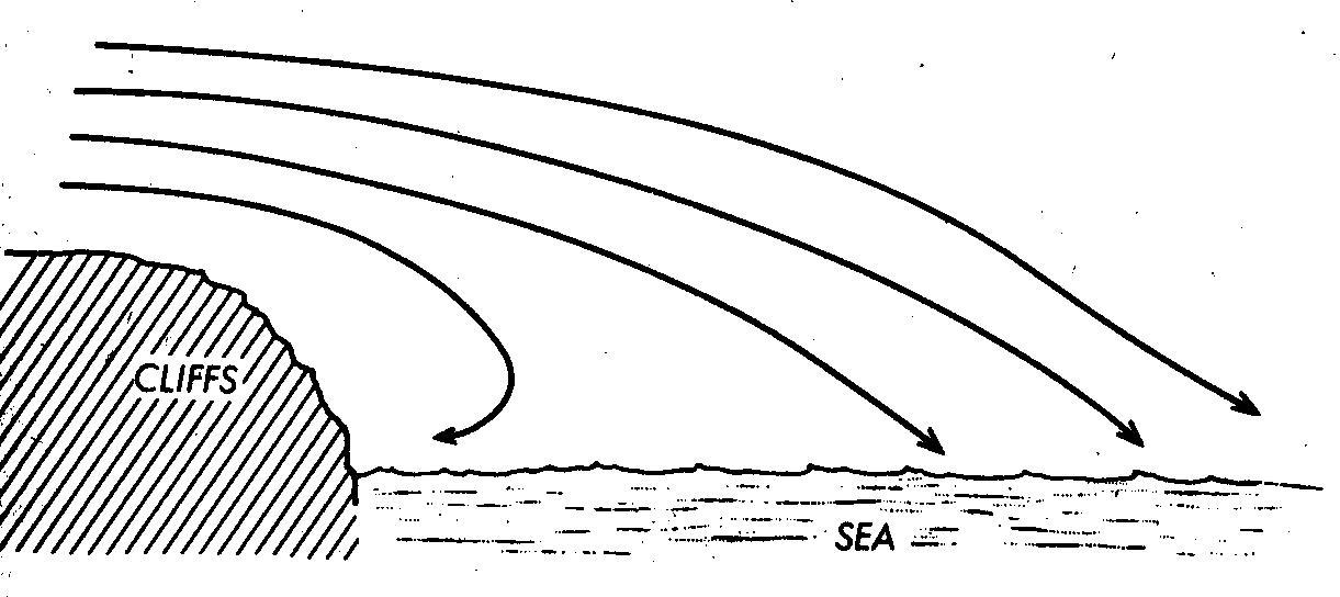
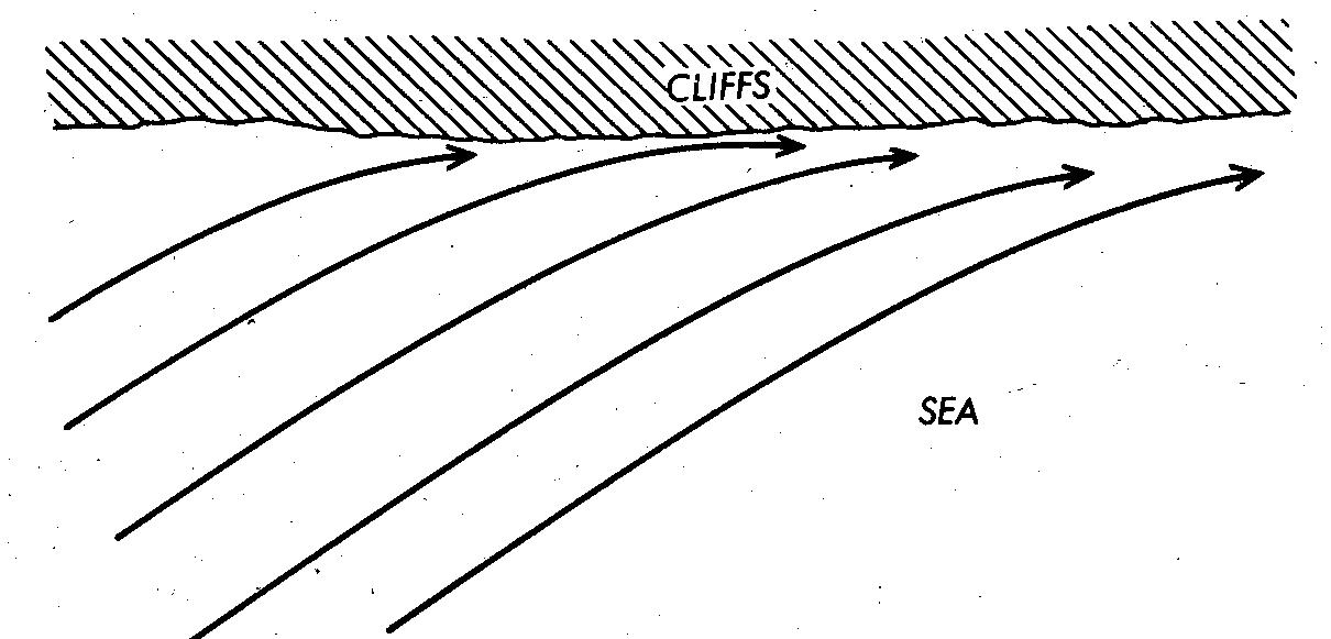
Winds blowing slantwise onto a steep coast line are likely to be deflected along the coast with an increase in the wind. č
Winds coming over cliffs splash down, often with considerable strength. In the marina at Darthaven in a strong westerly wind coming over Dartmouth, we seemed to be in a very windy spot with this effect Near the cliffs there may be a back eddy.
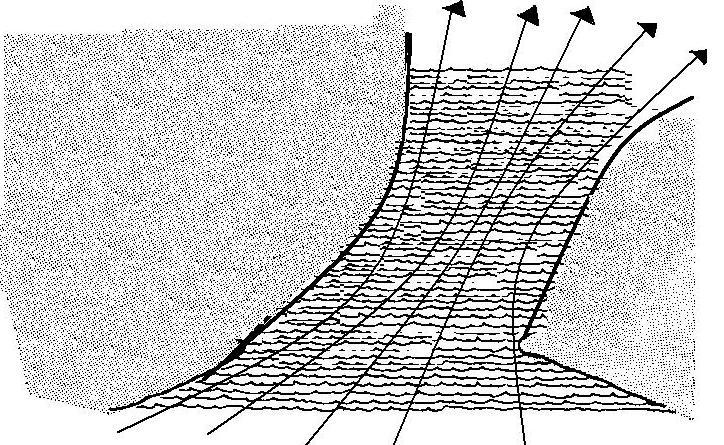
Winds blowing through straits are funnelled causing acceleration
There are, of course, many variations on this theme and I make no excuse for the amateurish nature of the diagrams. I have no artistic flair at all!
However, the effects shown are all ones that will not be indicated by many forecasts and definitely not by numerical weather prediction models, even some of those claiming to give detail on a 1 km scale.
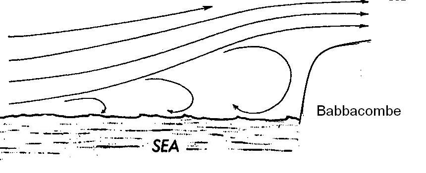
Winds blowing direct onto steep cliffs may lift off some way off and, also create a back eddy. Yachts have been known to anchor right under the Babbacombe cliffs in an onshore wind.
Complex topography has complex effects.
