


About this site
Marine weather forecasts are vital to safety for all sailors. This site sets out to be the most informed and most informative of sailing weather sites worldwide.
The emphasis is on understanding about weather and weather forecasts as the most important of all aids to safety at sea. Frank Singleton provides the major component of the MailASail Weather Window that gives quick and easy access to many forecasts. This is intended to become a collection of weather sites compiled by experts combined with the MailASail efficient data (free) download services for WiFi, cell or satellite phone.
Initially, most pages on this site were written recognizing the needs of those who are limited in bandwidth. Over the years that has changed somewhat and I have made more use of graphics. There are still no pop-ups, and graphics are often in thumbnail form but expandable. Click on the picture to enter the site.
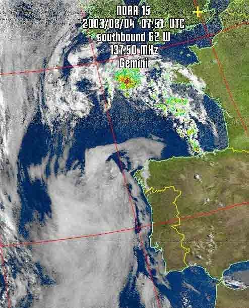 Click on the picture to enter main site This picture was provided by my friend and communications guru, Ross Biddle, skipper of Gemini, a 45 ft US built yacht with power supplies and computer hardware that make me green with envy. |
If you are a dinghy sailor, coastal cruising yachtsman, motor boater or a long distance, blue water sailor, then you will know that weather is important. Also, that weather is complicated as this satellite image, provided by a cruising yachtsman, shows. Weather services are also complicated and, although there are many very useful links to weather forecasts, few have any explanatory text. This site provides many links to forecasts that, from experience, are useful to sailors. Its object is to inform all sailors about weather, weather forecasts and how to use them. Forecast sources include many Internet sites as well as, and most importantly, the Global Maritime Distress and Safety System. To enter the site click on the Picture or this Home Page link. Starter | Beginner's Page]]. If you are beyond that stage, then try your hand with the links in the left hand bar. |
The nitty-gritty
There is much mystique attached to weather with old shepherds and old salts being credited with knowledge that they often do not possess. I hope that this site will help clear the mist a little. I take a very pragmatic view of weather forecasts and recommend that you do the same.
There are many textbooks on meteorology aimed at the sailing public. Some, to my mind, concentrate too much on the science and not enough on the understanding and use of forecasts.
Notable exceptions are
|
A comprehensive book on weather written mainly for European leisure sailors. It has much information on weather, weather forecasts and how to use them. This was first published in 2013.See.my Reeds Weather Handbook page.
|
|
This is a robust, quick reference source of weather infomation written and designed accordingly. Published in 2022.See.my Adlard Coles Skippers Cockpit Weather Guide page.
|
|
Probably out of print, but worth borrowing from a library. This has some good descriptions of coastal and orographic effects. Despite some weakness in the theory, it is a very practical work based on experience sailing dinghies in Chichester harbour and as a forecaster at Thorney Island. The book deals, mainly, with relatively small scale effects. |
|
Basic and designed to get you through RYA courses. Rather over simplistic. |
This site also contains bits and pieces of weather information not all of which can be found in the text books.
My Background - why I feel qualified to run this site
- I had a career in the UK Met Office and, in mid-career, was a senior forecaster at the (then) Central Forecast Office, Bracknell. I also worked at the Meteorological Research Flight, as a forecaster attached to the RAF in the UK and in the tropics, in applied climatology and personnel. My final post was as Director of the Observations Division. That encompassed branches dealing with everything from rain gauges to satellites.
- My wife and I sailed racing dinghies (mainly Fireflies) for many years but, as our knees began to wear out, we migrated to cruising and did much bare boat chartering including the Caribbean (10 trips and about 2500 miles) and one brief week in Turkey.
- After a Jeanneau Sunlight 31, we now sail a Hallberg Rassy 34. We have now cruised over 50,000 miles. Copies of our logs since 2000 when we went from Dartmouth to Barcelona are on my Cruising logs page. Fairly, I can claim to know about weather and sailing from both directions.
- I am a RYA Yachtmaster (Offshore) and sat on a MCA Marine Safety Information Group by invitation of the CYCC. I am very pleased to have been given various awards for work on this site.
Sailing Links
The site was set up, initially, at the suggestion of The Cruising Association for its members and those of The Hallberg Rassy Owner's Association. I am pleased that other sailors are finding the site useful and now have links from many other Clubs and Associations. Others are welcome to follow suit.
If you put a link to my site, then please let me know so that I can give a return link. There are many other links including National Met services, general weather sites, sailing schools, charter companies etc.
I am especially pleased to welcome the Sea Cadets. Any organisation that gets young (and not so young) people afloat is to be encouraged.
Most of the commercial sites listed offer good services to sailors and recognise this site. In particular, as a Dartmouth based sailor, (at least when in UK waters) I am very pleased to give a link to our old friends at Darthaven Marina.
Communications issues
At sea it is, of course, not always possible to use the web as a source of information. For that reason "old fashioned" radio links can often be necessary.
Increasingly, satellite communications are being used. My sponsor, MailASail will be only too pleased to advise a communications solution to meet your neds.
Feedback
Comments on the site in general and any queries or suggestions to Frank Singleton. I will try to respond reasonably quickly. However, we are likely to be away for much of the Summer half of the but can usually be contacted by email. I use the MailASail. email compression service. This converts all mails and Word documents to plain text. It holds picture and pdf files for me to recover at a later date. Thus there may well be a delay before I get a large email.