About this page
A general description of NAVTEX.
Related pages
- European NAVTEX weather broadcasts
- SOLAS and the GMDSS - how they apply to leisure sailors
- Sources of Marine Weather Forecasts
- NAVTEX reception problems
On this page -
- NAVTEX - Part of the GMDSS
- What is NAVTEX?
- How it operates
- What does it provide?
- Message format,
- How useful is it?
- Caveats
- National Frequencies
- Receiver or "engine"?
- Texts of mesages and forecasts, lists of stations
NAVTEX - Part of the GMDSS
NAVTEX, (NAVigational TEXt) is described by UK Coast Guard (HMCG) as the primary method of disseminating Marine Safety Information (MSI) out to 270 miles and is part of the integrated Global Maritime Distress and Safety System (GMDSS). As the name implies, it provides information in text. The other components of the total GMDSS are:
- Radio telephony broadcasts, VHF out to 30 miles, MF to 150 miles, HF worldwide,
- The International Maritime Satellite (Inmarsat) SafetyNET over the oceans, roughly 65°N to 65°S.,
- HF/SSB/SSB radio-facsimile and radio-teletype.
NAVTEX is obligatory for Safety of Life at Sea (SOLAS) convention vessels, including some training yachts. This page gives a basic description of NAVTEX, how it operates, where and when it is useful. Another page discusses reception issues.
Terms used in marine forecasts are on another page of this site.
What is it?
NAVTEX broadcasts text messages over radio for automatic reception. Specifications are that it should be capable of reception at sea (specifically, from the fairway buoy) to between 250 and 400 nm offshore. The GMDSS system is designed on the assumption that there are other ways of receiving safety information, when in harbour or near the coast. International NAVTEX broadcasts all use a common frequency of 518 kHz (obviating the need to tune a receiver) and are in English.
Dedicated NAVTEX receivers are pre-tuned Single Side Band radios with signal processing software. Although coverage is generally good around Europe, there are many areas not served by NAVTEX and it is important to consult the coverage maps to be found in most almanacs and Admiralty publications. See the ICS/McMurdo site for a list of transmitting stations worldwide.
For a formal description of the design and operation of the NAVTEX system, see the IMO NAVTEX Manual, a PDF document. There is a “layman’s” description on Martin Stubbs’ site.
How does it operate?
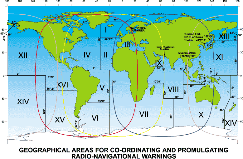
In each meteorological area (METAREA) NAVTEX transmitters are allocated single ID letters from A through to X. Station A broadcasts from 0000 to 0010, station B from 0010 to 0020, …, station X from 0350 to 0400 UTC. This cycle is then repeated six times daily. Message types (see below) are also given single letter IDs.
(With acknowledgement to Inmarsat)
A set will receive all transmissions within reception range; users select which stations and message type it is wished to record. Older leisure and SOLAS standard sets produce paper printout; most modern leisure sets store the data for viewing on screen.
It is sensible to select IDs for both the area where you are sailing and where you are going to.
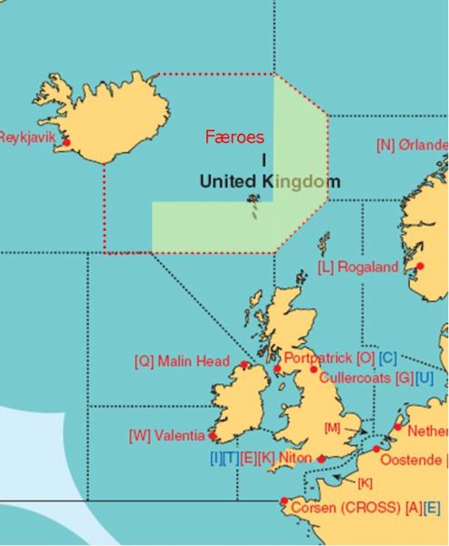
The information in a NAVTEX broadcast will normally refer to the service area for the transmitting station. This shows areas around the British Isles these are shown here.

What does it provide?
MSI in categories indicated by single letters; there are more than those listed here, but these are the ones most relevant to the leisure sailor -
A......Navigation warnings
B......Meteorological warnings
C......Ice reports
D......Search & rescue information, piracy warnings
E......Meteorological forecasts
L......Navigation warnings - additional to letter A - see below
V......Weather actuals – only on UK 490 kHz
Most leisure sets allow all message types to be de-selected apart from D. It is usually advisable to select messages A, B, E and L. On SOLAS standard sets, none of A. B. C. D can be de-selected.
Message format
Messages are ‘topped and tailed’ by codes used by your set to decide whether it should be saved.
The message layout is -
ZCZC
B1,B2,NN
Time of transmission
Message Text
...
NNNN
ZCZC starts a message, B1 is the station ID.
B2 is the message ID
NN the message number 01 to 99..
Time of broadcast is in UTC.
The message follows and is ended by NNNN meaning end of transmission.
On SOLAS standard sets, the message number is used to prevent repeated printing in hard copy. With soft copy, leisure sets, it allows the user to ignore messages already received and read.
A Gale Warning (B) from Hamburg (S) might look like this
ZCZC SB74 2*WEPP NAVTEX-HAMBURG (NCC) WARNING NO. 95 291710UTC AUG FOR GERMAN BIGHT: GALES NORTH TO NORTHEAST 7 TO 8 BFT. NNNN.
NOTE The date time group is corrupt and should have read 292300. See my RTTY page for suggested "decodes" of corrupt messages..
How useful is it?
Coastal sailing
Within 30 miles of the coast ie within and making short passages, relevant weather information is usually available on VHF supplemented by other means, especially the Internet. NAVTEX can be regarded as a back-up for “Sea Area” forecasts such as the UK “Shipping Forecast” or the French “Bulletins au large.” Even around the UK, there are dead spots for marine VHF and mobile phone networks. In some areas (eg Croatia, Italy, Greece) where the forecasts on VHF are identical to those on NAVTEX, the text of the latter can be easier to understand than when read in heavily accented English, sometimes at great speed.
Another benefit is the easy receipt - and easy reading - of Navigation warnings. These can be tedious to listen to, especially when broadcast on VHF in two or three languages.
Offshore
HMCG recommend NAVTEX for non-convention vessels going over 30 miles out, On passage, messages will normally be received from stations at least 200 nm away and often more, as long as the signal has passed mainly over the sea.
For those going into blue water, the equivalent system is the Inmarsat SafetyNET.
National NAVTEX and other frequencies.
National NAVTEX services usually use 490 kHz. This may be received automatically on some dual-channel receivers but have to be selected on others. Older sets usually only have the 518 kHz channel... The UK uses 490 kHz for inshore waters forecasts and weather actuals. Most other countries use this frequency for national language versions of their 518 kHz broadcasts. For those going further afield, there are some other frequencies eg 424 kHz in Japan and a 4209.5 kHz used by Egypt, Turkey, Taiwan and Vietnam.
Caveats
- NAVTEX is not intended to be capable of reception in harbours although it often can be.
- The night-time effect, when transmissions from distant stations sometimes over-write a nearby station, is an insoluble problem.
- Speeds are slow. The technology is 1950s but is low cost. It works fairly well in the areas where it is supposed to work. It does not work well in areas where it is not intended to work. In such areas, GMDSS service are provided by VHF, MF/HF or Inmarsat as appropriate.
Dedicated set, "NAVTEX Engine", or radio input to computer?
Because NAVTEX is intended for unattended operation, the dedicated set must be the optimum solution. There are some devices on the market that are designed to feed the signal to a computer and/or store the information for later viewing.
Use of a computer is fine if yours is built and marinized so that it can run continuously at sea. For small boats there are lox cost solid state laptops that might serve as well if they can be protected from water and physical damage and on a windy, wet passage. The need to be able to view messages as and when received may make such an option not a good idea for the ordinary coastal sailor. The idea of saving the data for later viewing is incompatible with the NAVTEX concept when at sea.
Texts of NAVTEX messages
In poor reception conditions there may be numbers in place of letters or vice versa. These may well be the same as occur with RTTY which, like NAVTEX, was originally a teleprinted keyboard. I have put some NAVTEX text decodeson another page.
The IMO/WMO WWMIWS site is a reliable source of texts of all UK NAVTEX broadcasts and from some other countries.
NAVTEX messages received from various sites around the world,can be seen at http://www.frisnit.com/cgi-bin/navtex/view.cgi. The system obtains the information from a network of shortwave receivers and PCs running decoder software. Messages for the UK and Eastern Mediterranean are usually available. The messages are uploaded to the site automatically, as soon as they are received from the NAVTEX transmitters. Typically the delay is less than 10 seconds.
DWD has a similar service for messges on 518 and 490 kHz transmissions received at Emden and Rostock.
Other sites about NAVTEX
- NAVTEX history
- List of NAVTEX stations that will meet most needs
- An exhaustive list of all NAVTEX stations and schedules
Return to Home Page

