
This page refers to JVComm. Unfortunately, JVComm no longer exists.
About this page
Use of RadioTeletype (RTTY) has received a boost since NASA Marine introduced the Weatherman receiver. But, what is RTTY and why is it useful to sailors? A separate page deals with some reception problems.
Related pages
- A novice's view about HF reception problems
- Northwood Radio Fax Schedule and DWD
- Marine HF, Amateur Radio, Telephone or INMARSAT?
On this page -
Do I need RTTY?
I sometimes get asked "Should I have NAVTEX or the NASA Weatherman?". My usual reply is "Both!" If not Weatherman, then have an HF/SSB receiver, with laptop and decoding software.
To understand the question and answer we need to know about RadioTeletype (RTTY). This is old technology but is still used in some parts of the world. Around Western Europe and throughout the Mediterranean it provides a useful forecast service that complements other GMDSS services that sailors will receive via Marine VHF, NAVTEX and Inmarsat-C. The DWD has said that they intend to continue the service despite rumours to the contrary. ( See the Yachtcom site for much good advice on marine radio communications.)
So, What is RTTY?
RTTY is a system for broadcasting text over radio. The technology dates back to the late 1950s and seems somewhat anachronistic. Speeds are slow, even slower than NAVTEX. A similar service is the USCG service, SITOR (Simplex Teletype Over Radio) providing offshore and coastal forecasts over very wide and remote areas from the tropics to the polar regions.
There is dedicated equipment to receive RTTY and SITOR but we can receive both using a standard HF/SSB receiver with software packages such as TRUETTY and SEATTY to decode the signals.
The main advantage of RTTY/SITOR is the reception of information over an entire ocean area. The USCG also shares frequencies across multiple transmitters according to a schedule, rather like NAVTEX. The system is available over the Atlantic and Pacific including polar regions not served . For more about SITOR see the Monitoring Times link or the USCG site.
Around Western Europe and the Mediterranean, the Deutscher Wetterdienst (DWD) , the German Weather Service has accepted the responsibility to broadcast weather information for mariners on RTTY. Frequencies are as in the table below.
DWD Frequencies
|
Frequency |
Call sign |
Times of broadcast |
Power |
Class of emission |
Band |
Shift |
|
147,3 kHz |
DDH 47 |
05.30 - 22.00 UTC |
20 kW |
F1B |
50 Baud |
+ / - 42,5 Hz |
|
11039 kHz |
DDH 9 |
05.30 - 22.00 UTC |
1 kW |
F1B |
50 Baud |
+ / - 225 Hz |
|
14467,3 kHz |
DDH 8 |
05.30 - 22.00 UTC |
1 kW |
F1B |
50 Baud |
+ / - 225 Hz |
|
4583 kHz |
DDK 2 |
00.00 - 24.00 UTC |
1 kW |
F1B |
50 Baud |
+ / - 225 Hz |
|
7646 kHz |
DDH 7 |
00.00 - 24.00 UTC |
1 kW |
F1B |
50 Baud |
+ / - 225 Hz |
|
10100,8 kHz |
DDK 9 |
00.00 - 24.00 UTC |
10 kW |
F1B |
50 Baud |
+ / - 225 Hz |
DWD (Hamburg) Broadcast Content
Some broadcasts are of raw weather observations in a WMO coded form. These are not readily useful to sailors - but see below and the Appendix..
Otherwise, for the broadcasts include
- Strong wind, gale and storm warnings for German Bight, Western and Southern Baltic Sea, German North Sea and Baltic Sea coast
- Weather forecast for the North Sea and Baltic Sea , Weather situation, forecast valid for 12 hours and outlook valid for another 12 hours
- Weather report German North Sea and Baltic Sea coast, Weather situation and forecast valid for 12 hours.
- Navigational warnings for North Sea, Baltic Sea and German coast
- Weather report Norwegian Sea and Baltic Sea Route North Cape - Shetlands, The Quark - Gulf of Finland. Weather situation and time series forecast for 2 days
- Weather report North Atlantic. Route Pentlands - Southwest Greenland. Weather situation and time series forecast for 2 days
- Station reports North Sea and Baltic Sea
- Weather report Western European Sea . Route Southern Ireland - Area Canarias. Weather situation and time series forecast for 2 days
- Medium range weather report North Sea , Weather situation and time series forecast for 5 daysFor the Mediterranean there are
- Station reports Mediterranean Sea
- Weather report Mediterranean Sea (in German), Weather situation and forecast valid for 24 hours.
- Alborán - Tunis. Weather situation and time series forecast for 2 days
- Weather report Eastern Mediterranean Sea (in German). Route Eastern Tunis - Rhodes/Cyprus. Weather situation and time series forecast for 2 days
- Medium range weather report Mediterranean Sea (in English), Weather situation and time series forecast for 5 days
Around the North Sea and the Baltic this service is a useful supplement to NAVTEX. Particularly so are the 5 day outlooks, These give wind forecast every 12 hours for the 5 day period. The values are straight from the DWD NWP model at a few grid points although these are sufficient to give an overall view and much quicker to receive than synoptic charts on radio fax.
In the Mediterranean, most valuable is the 5 day forecast which seems to be used and very highly regarded by the majority of serious cruising yachtsmen. It is a most valuable service for predicting the major strong wind systems such as Mistrals, Libeccios, Tramontanes etc. Such winds are usually well predicted 4 and often 5 days ahead. Conversely, I have never found the 24 hour forecast to be much use. For this period, the French, Spanish and even the Italian NAVTEX broadcasts are to be preferred.
The two DWD programme schedules are available here
- Quickborn/Pinneberg(DWD) radio-telex Met broadcast (Program 1) and
- Quickborn/Pinneberg(DWD) radio-telex Met broadcast (Program 2
USA
Nowadays, there is very little on SITOR of use in terms of weather. For details, see the USCG Marine Weather Page.
How to Receive RTTY- Dedicated HF/SSB radio
There are two options. Most blue water sailors are likely to have HF/SSB transceivers. Those, like me, whose passages are mainly not too far from the coast, may not want or need to get involved in marine or HAM HF radio licensing. For us, there are receive only HF/SSB radios. Like most things in this world you get what you pay for and some may prefer top of the range sets. However, I have used the very budget priced NASA HF3 for several years and with great success.
Using a laptop, the normal procedure is to connect the radio to the sound card of the laptop and use proprietary software. We bought the SEATTY software for about $US30, and found it excellent. It seems to unscramble messages when reception poor.
An alternative packageis available from Mscan Meteo. These are more comprehensive and multi-purpose packages that will also handle radio fax, SITOR and GRIB coded information. Mscan has many more bells and whistles for RTTY than SEATTY and these might be useful for North Sea and Baltic sailors. It may be more appropriate to commercial vessels. But, the best advice is to try the various options and see. In the Med, we did not find a great deal of use for Radio fax so that SEATTY was quite sufficient.
For Apple Mac users there is a dedicated Mac RTTY programme, Multimode lite OSX. It is similar to the PC programme and can be found at ''' http://www.blackcatsystems.com/software/multimodeOSX.html
The NASA Weatherman
This is a radio receiver pre-tuned to 4 frequencies - 4583 kHz, 7646 kHz, 10100,8 kHz and 11039 kHz. Simply select which programme is most appropriate for content and reception conditions. These will vary during the day so that reception is not completely automatic. Messages are retained in soft copy and can be scrolled through in the same way as the NASA NAVTEX sets. I have had many good reports of the Weatherman from sailors around western Europe and the Western Med. It should do well in the Eastern Med also.
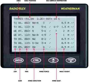
The ability to leave the set running whilst at sea must be a big plus. Laptops are not designed to be bounced around and hate getting wet. I, normally, only use mine when in port or at anchor. Like most marine radios, a good aerial and earth are essential for Weatherman. With my HF3 set, I use the NASA active aerial to good effect.
The Weatherman, shown here by courtesy of NASA , illustrates the display from the 5 day forecast of winds at grid points. The points are fairly sparse. Two points are in the English Channel. One is in the bay of Biscay but, rather curiously, this appears near the end of the Mediterranean 5 day forecast! See the example on another page.
A slight drawback to the Weatherman is that it will only receive RTTY messages. If Radio fax is required then a separate receiver will be necessary. If space permits, then the ideal solution is to have NAVTEX, Weatherman and an HF/SSB receiver. Another drawback to Weatherman in the Mediterranean is the choice of frequencies. 4583 MHz will be of little use while the 14467
might be useful, particularly in the eastern Med.
Coded Reports
Weather observations are exchanged internationally using numerical codes consisting of 5 figure groups. These describe all possible weather, wind, visibility, cloud etc etc. Code forms can be found in Admiralty publications. There is software available which can decode the data and plot them onto a background map in the Appendix. In addition, the packages can "analyse" the data and draw isobars. At first sight this should be a useful addition to the yachtsman's weather services. However, in meteorology, as in life, nothing is that simple. The data are "raw" and as received. Errors occur and the software is simply not clever enough to deal with poor data. National weather services running their massive computers put a vast amount of effort into dealing with suspect data using sophisticated and complex quality control methods. To ignore a suspect but correct observation near a developing depression can be as equally disastrous as accepting an erroneous observation.
In short if you use such software then concentrate on just looking at the data and be very careful if trying to use analyses.
Dealing with corrupt messages
Teleprinter keyboards have only three banks of keys and no lower case letters. If a character shift gets lost then character transpositions occur such as Q, W, E, R, T, Y, U, I, O, P for 1, 2, 3, 4, 5, 6, 7, 8, 9, 0. The decimal point . is on key M, the slash / is on X and the hyphen - is on A. Other possibilities are + (plus) for Z, a : (colon) for C, = (equals) for V, ? (query) for B, , (comma) for N, n ' (apostrophe) for S, a # (hash) for D, a ( (open brackets) for K and a ) (close brackets) for L.
Thus, PMT could be 0.5 (for wave height) and EAR could be 3-4 for wind force. PPZ will be 00Z, QW, where a time might be could be 12. Conversely, a 2 or a 3 where a wind direction might be could be West or East. I download on to my laptop and then try to make sense of such garbling.
Appendix
Coded reports - decoded'''
Messages received in code might look like this for observations received from ships and data buoys. At the start of each message, the four letter/figure groups are ship call signs and the five figure groups beginning 63xxx or 64xxx are indicators for data buoys. Each message is terminated with an = sign. These were received using JVcomm.
ZCZC
457
SIVX42 EDZW 200900
BBXX
LDWR 20091 99659 10017 41398 71004 10030 21021 40145 53003
78582 8697/ 22200 04064 20805 304// 40805 5////=
63101 20094 99612 10009 46/// /0607 10053 40131 52012 22200=
63103 20094 99612 10011 46/// ///// 10064 21019 40134 52012 22200
10805 70025 80029=
63105 20094 99610 10017 46698 /0507 10051 21031 40129 52014 22200
80019=
64046 20094 99606 70049 46/// /16// 10088 20050 40102 52006 22200
00101=
3FYT 20091 99608 10036 41/98 70000 10038 21029 40133 52015 70222
8436/ 22200 06075 10804 70021=
LF3F 20094 99643 10078 41598 60910 11002 21048 40151 52018 70222=The same text decoded, again with JVcomm, gives the following synoptic data;-. SHIP messages BBXX ==========================================================================
Station: LDWR
Position: 65.9° N, 001.7° E
Time of observ: 200900 UTC General
-------
Visibility: 20 km
Wind: 100°, 4 m/s (measured)
Temperature: 3.0 °C, dew point: -2.1 °C
Pressure: 1014.5 hPa (MSL)
Press. tendency: +0.3 hPa, decreasing or steady, then increasing Weather
-------
Present: light snow showers
Past: showers, cloud covering > 4/8 Clouds
------
Total coverage: 1/8, base of lowest: 200 to 300 m Sea surface observations
------------------------
Ship speed: not moving
Primary swell: 040°, period: 8 s, height: 2.5 m ==========================================================================
Station: 63101
Position: 61.2° N, 000.9° E
Time of observ: 200900 UTC General
-------
Wind: 60°, 7 kts (measured)
Temperature: 5.3 °C
Pressure: 1013.1 hPa (MSL)
Press. tendency: +1.2 hPa, increasing steadily Sea surface observations
------------------------
Ship speed: not moving ==========================================================================
Station: 63103
Position: 61.2° N, 001.1° E
Time of observ: 200900 UTC General
-------
Temperature: 6.4 °C, dew point: -1.9 °C
Pressure: 1013.4 hPa (MSL)
Press. tendency: +1.2 hPa, increasing steadily Sea surface observations
------------------------
Ship speed: not moving
Wet bulb. temp.: 2.9 °C, measured
Wave height: 2.5 m, period: 8 sec.
Wave height ins.: 2.5 m ==========================================================================
Station: 63105
Position: 61.0° N, 001.7° E
Time of observ: 200900 UTC General
-------
Visibility: 20 km
Wind: 50°, 7 kts (measured)
Temperature: 5.1 °C, dew point: -3.1 °C
Pressure: 1012.9 hPa (MSL)
Press. tendency: +1.4 hPa, increasing steadily Clouds
------
Total coverage: 0/8, base of lowest: 1000 to 1500 m Sea surface observations
------------------------
Ship speed: not moving
Wet bulb. temp.: 1.9 °C, measured ==========================================================================
Station: 64046
Position: 60.6° N, 004.9° W
Time of observ: 200900 UTC General
-------
Temperature: 8.8 °C, dew point: 5.0 °C
Pressure: 1010.2 hPa (MSL)
Press. tendency: +0.6 hPa, increasing steadily Sea surface observations
------------------------
Ship speed: not moving
Sea surf. temp.: 10.1 °C ==========================================================================
Station: 3FYT
Position: 60.8° N, 003.6° E
Time of observ: 200900 UTC General
-------
Visibility: 20 km
Wind: 0°, 0 m/s (measured)
Temperature: 3.8 °C, dew point: -2.9 °C
Pressure: 1013.3 hPa (MSL)
Press. tendency: +1.5 hPa, increasing steadily Weather
-------
Present: state of sky unchanged
Past: cloud covering > 4/8 Clouds
------
Total coverage: 0/8, base of lowest: unknown Sea surface observations
------------------------
Ship speed: not moving
Wave height: 2.0 m, period: 8 sec.
Wave height ins.: 2.1 m
!! And to plot/analyse?
Using a bigger dataset (and from a different day) this is an example of a file received by HF/SSB as synoptic type 5 letter groups from Hamburg RTTY and analysed by Digital Atmosphere. The options selected were plots of individual inputs, sea level pressure (mb or hPa) and the wind field.
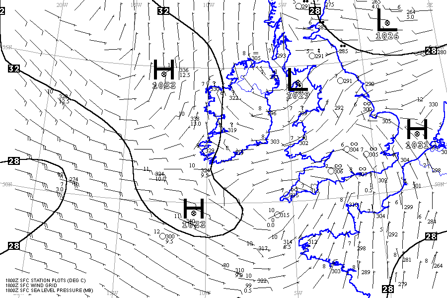
This example was provided by Ross Biddle, skipper of Gemini a (slowly) circumnavigating Australian, a great friend and communications mentor of mine. Ross has corrected (or tried to correct) my many misunderstandings about short wave (HF) communications.
Return to Home Page