
What this page is about
GRIB forecasts for 7 days are shown against what actually happened.
Updated October 2016.
Related pages
- MCA figures on "accuracy" of Inshore Waters Firecasts
- Data used in NWP
- Limitations of Forecast Accuracy.
Preamble
Meteorologist continually assess their numerical weather forecasts, especially when they have made changes to their forecast programs and analysis techniques. Although useful to them, measures such as the Root mean Square Error of surface pressure mean little to us sailors. Model performance for wind forecasts can be given as Root Mean Square Vector Error but, again, these mean little to us.
The example shown here is from an English Channel crossing in 2016. Further down there are PDF files from a few years earlier.
September 2016
We were in St Peter Port, Guernsey wanting to cross to Dartmouth. About 72 miles on a course of about 315 degrees from Platte Fougere Light to the Dart.
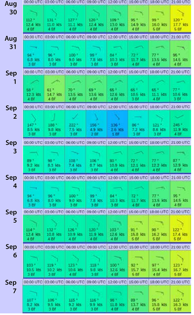
This shows forecasts all for 7th September for a point in mid-Channel. All are from the US GFS. Typically, they are available by about 0600 UTC. Forecasts are for 3 hour intervals from 00 UTC and are based on data for 31st August through to 7th September.
From about 2nd September it was becoming obvious that Wednesday 7th September would be a good day to cross. Monday could well have been OK but we thought that the winds might become too fine a reach to maintain a reasonable speed without using the engine. Tuesday looked like being too light to sail across. Thursday, not shown here, was also possible but with winds possibly up to F7, we would certainly have had to take in one or two reefs. Wednesday was the best day.
In the event, it was a good fast sail. We did use some engine through the eastbound Traffic Separation Scheme just to maintain a constant speed as ships were coming thick and fast. Winds did increase as expected after noon, almost to needing one reef. We sailed into and up the Dart dropping the sails 11100 metres short of Darthaven.
This level of consistency between successive forecasts is a good indication that the computer models will be giving good and useful guidance. When forecasts are inconsistent it indicates that forecasts cannot be relied upon more than a day or so ahead and that plans should not be made too firmly. In this case we were able to give good advance warning to family and friends that we would be arriving on Wednesday evening with an accurate ETA.
More examples
These are pdf files copied from PowerPoint. Page down each to see the sequences and how they worked out. Make your own judgement as to potential use.
|
Area of Forecast |
Comments |
|
Western Mediterranean |
This was before the enhancement to the GFS in mid-2010. |
|
Central English Channel |
Days 1 to 5 were good, Day 6 was poor, Day 7 rather better |
|
The Baltic |
Days 6 and 7 were poor |
|
Waters around Scotland |
Pretty good in general. Not misleading apart from Day 7 |
|
English Channel and Biscay |
Day 1 was not very good, but winds were light and variable. Otherwise good. Days 6 and 7 not misleading |
|
Eastern Mediterranean |
Despite some rather light and variable winds, a pretty good shot |
|
Southern North Sea, E Channel and SW Approaches |
This is after the last major enhancement of the GFS has had time to settle down. Good to about 6 days but a timing error at day 5. |
|
English Channel and SW Approaches |
Poor on Day 3, but otherwise good guidance until Day 6. Poor thereafter. |
|
English Channel and SW Approaches |
Poor in south on Day 7. Poor day 8. Good otherwise. |
You can make up your own mind about the usefulness of these GRIB products. I suggest that using them as planning tools would rarely be misleading to 5 days ahead.