
Revised Match 2021.
About this page
Grid length and resolution in NWP (Numerical Weather Prediction) are not synonymous
Related pages
- Why are forecasts not more accurate?
- Accuracy assessmen of UK Inshore waters forecasts
- How the weather is calculated
On this page -
- Grid Length and resolution
- Representing topography
- Representing weather
- What short grid lengths can do!
- The future and a warning!
Introduction
My page on NWP talks about Global and meso-scale models but sidesteps the important issue of grid length and model resolution.
Grid length
NWP models have to calculate on a 3 - dimensional grid of points. The nearer the points are together, the better will the model represent the atmosphere and topography. A practical problem is that small horizontal grids need more levels in the vertical and shorter time steps. This requires more computing power.
A global model is needed to produce day to day forecasts with outlooks for the next few days. Available computing power in 2018 limits grid lengths to between about 9 km for ECMWF, 10 km for the UK and 13 km for the GFS (USA) and ICON (German) models. For short period, local forecasting short grid lengths are used over small areas. These grids range from 1 km up to about 7 km.
Representing topography
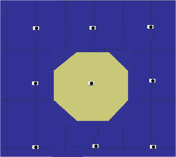
Look at a 25 km (15 NM) grid around the Isle of Man. This is the grid that was used for output from the US Global Forecast System model in 2015 and is the output grid. As will be seen here, there can be at most two grid points over the IoM, quite likely only one or even none.
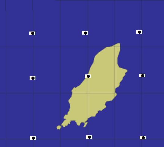
It would need a grid length of about 2 km to give a general outline of the island and, even then, it would not represent the headlands and bays. With just one grid point over the island, the computer will think that it looks something like this -
Given that a 25 km grid length model will not be able to represent the IoM, imagine the same grid over Torbay or the Solent. It will become clear that to represent these areas, grid lengths of about 1.5 km would be needed for Torbay and under 1 km for the Solent. To model Start Point would need a grid length measured in 10s of metres, perhaps 100 metres at most.
The same applies to weather on these size scales.
Representing weather
The atmosphere is a continuum but numerical models can only calculate on a finite grid. As a result, there are small differences between the physical processes in the real and model atmospheres. These differences can lead to unreal developments and computations can become unstable. In addition, must of the physical processes that drive the atmosphere cannot be calculated accurately. There are approximations and estimates.
All models whatever the grid length have this problem. The solution is for a continual filtering out of small detail – small, that is, relative to the grid spacing. The degree of filtering or smoothing is determined by experiment. The Met Office, in 2004, quoted an effective resolution as about 4 or 5 grid lengths. More recently, a Royal Society report and a study at ECMWF suggested values around 6 or 7 grid lengths for the ECMWF and ICON models.
Thus a 0.1 degree (10 km) grid length model will provide forecasts only for features of scale 0.5 degree, 50 km, at best. Such features might have a lifetime, therefore a natural predictability of, perhaps, 6 to 12 hours at best.
Shorter grids, say around 2 km can model weather down to about 10 km size but such features will have lifetimes under 5 or 6 hours. Watch a large cumulus cloud grow and disappear within a matter of a couple of hours or so.

What short grid lengths do for us
Even if detail at, say, a 1 km (0.5 NM) scale could be observed accurately, and we had a perfect prediction model (which we have not), it is unlikely that it (ie the detail) would still be there by the time a 6-hour forecast was produced and made available to users.
The biggest benefits from short grid length models will probably be in the prediction of:
- Topographic effects determined by the large scale pattern.
- Small disturbances, such as trough lines, in the general pattern.
Both up to about 24 hours ahead, and
- Organised convective storms over the next 6 to 12 hours.
Observing small, locally generated weather requires observations that are truly on the very small scale – eg satellite and radar imagery. These both give an effective observation spacing of around 5 km. Over the sea, of course radar data are only available to a fairly short distance from the coast.
In practice, there are, quite simply, not enough data to define the very small weather detail that sailors observe over the sea. Satellite (ASCAT) wind measurements look impressive but are only able to resolve detail on about a 25 km scale. Over land, data from radar can be used to help predict small scale and short lived detail.
Reducing grid lengths in global models will improve performance in predicting the larger scale evolution. For example, better analysis of detail around a developing low will improve prediction in the short, 24 hour term This will have a knock on effect in prediction of large scale patterns over the UK at 4-5 days ahead. The current (2018) 0.1 degree (11 km) can define weather on a scale of some 40+ km. However, such features have lifetimes of <24 hours.
How much grid lengths can be reduced in global models is uncertain and will depend on observational data – as well as computer power. The future is likely to be one of finer resolution global models but with not a great improvement on short term, small detail over the sea.
The future?
The major benefits of fine scale models are likely to be for prediction of heavy showers over land, clearing skies leading to fog or ice on roads. To focus on the specific needs of sailors. a NWP model with very short grid lengths will offer improvements in the following areas:
- More realistic representation of the impact of topography on coastal winds and weather on such scales as the strong winds through the Dover Strait.
- More reliable forecasts of small scale thundery troughs and the like.
- More reliable forecasts of the development of organised convection systems, with associated severe weather.
Useful gains might be furthest ahead for the first area, less for the second, and perhaps only 12 hours for the third.
And a warning note
Short period, small scale prediction requires high resolution data. Without such observational data, claims for forecasts to be -
....exceptionally accurate
....high-resolution
....precise high quality,
Incredible detail....
....down to 1km resolution
Are meaningless.