Weather Charts on the Internet

About this page

Links to weather charts from the UK and other national Met services. Brief exlanations for these are given by links to another page.


On this page -

European Met Service charts

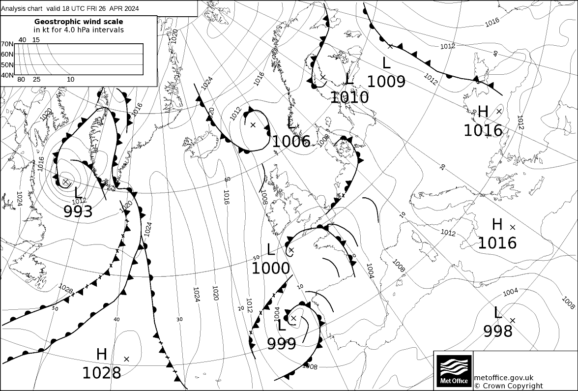
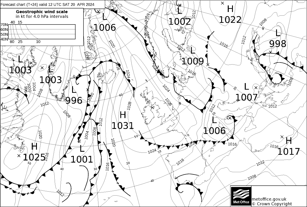
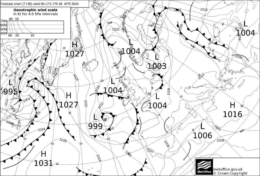
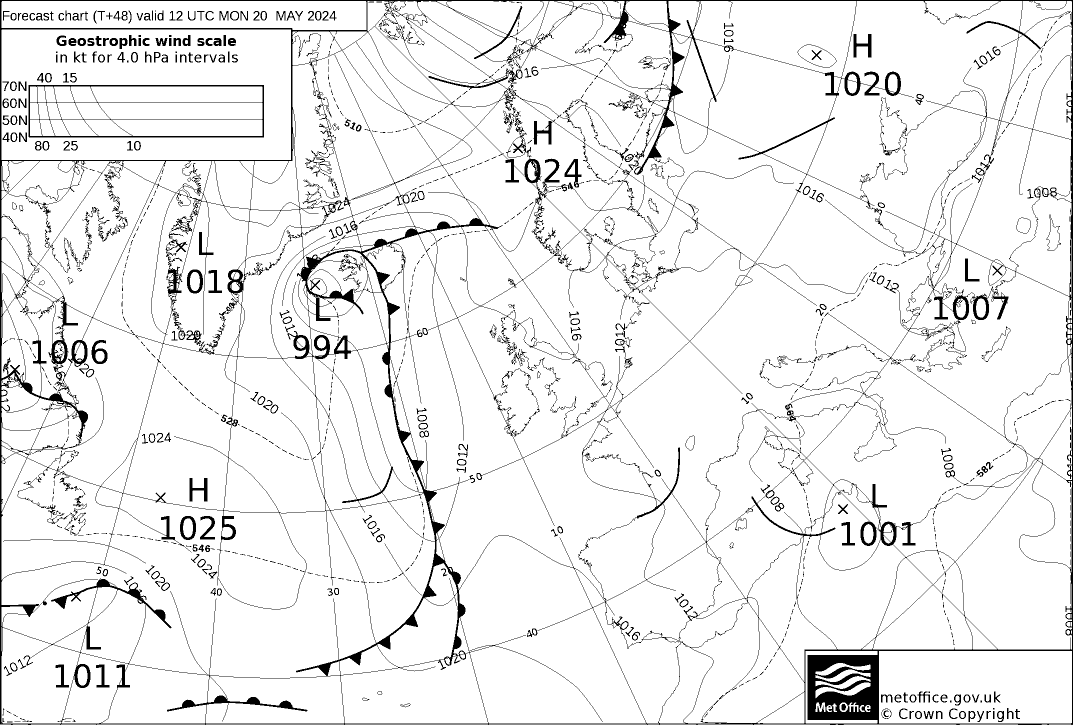
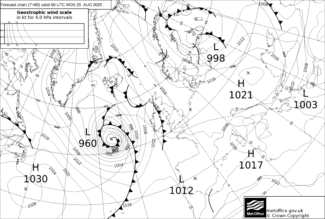
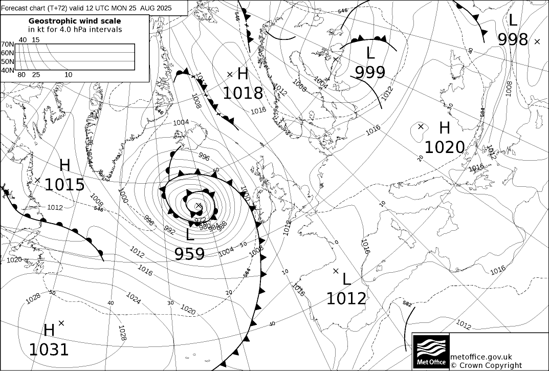
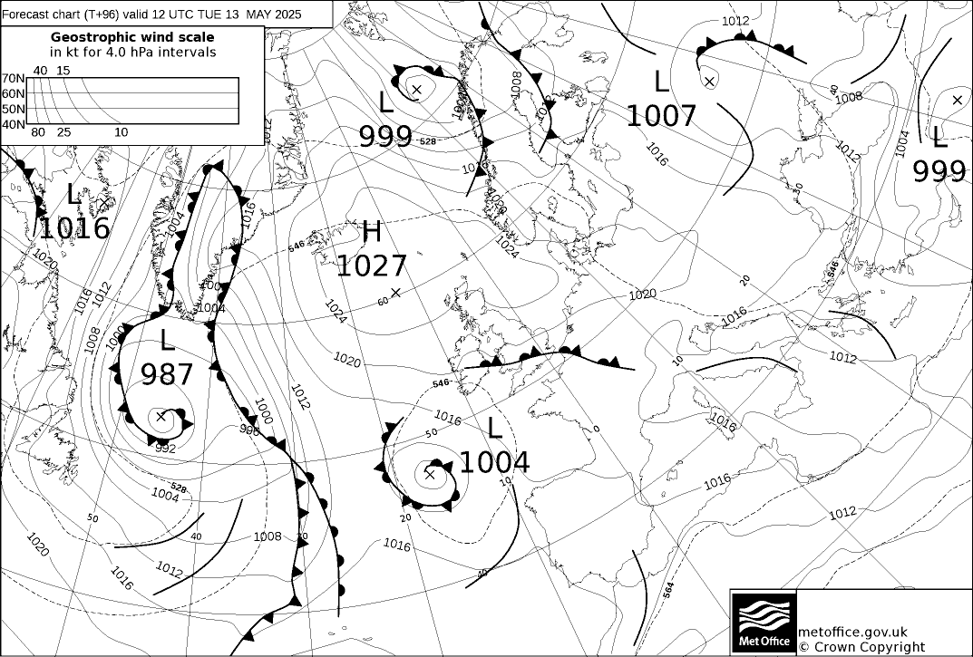
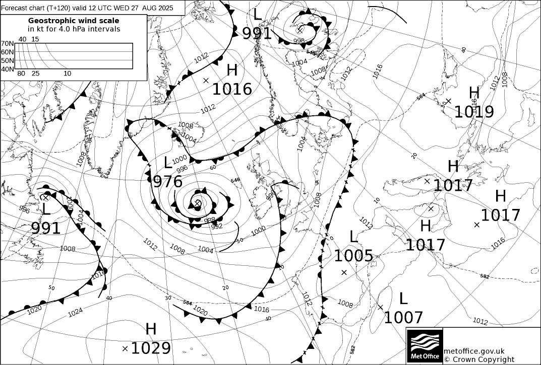
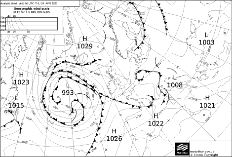
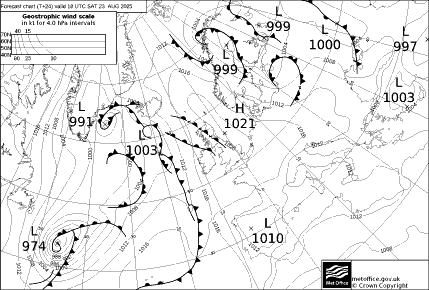
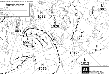
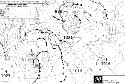
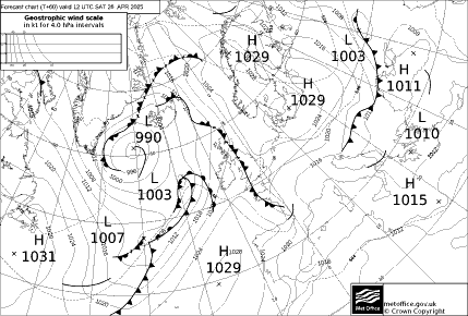
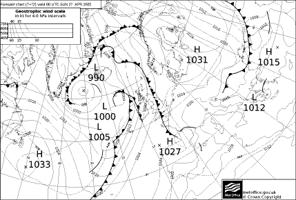
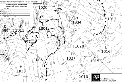
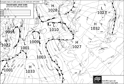
UK Met Office Charts - Isobars and fronts - North Atlantic/Europe.

See explanatory notes on the Essential page.

Links are given here; the size of each chart is about 60 kb which is significant if using a cell or satellite phone connection.

Analysis ~60KB
Small version ~15KB

24-hour Forecast ~60KB
Small version ~15KB

36-hour Forecast ~ 60KB
Small version ~15KB

48-hour Forecast ~ 60KB
Small version ~15KB

60-hour Forecast ~60KB
Small version ~15KB

72-hour Forecast ~60KB
Small version ~15KB

96-hour Forecast ~60KB
Small version ~15KB

120-hour Forecast ~60KB
Small version ~15KB

Times of issue

  • Analysis charts are usually available by HH+0320
  • 24-hour forecasts by HH+0520
  • T+36 and T+48 forecasts by 0620/1820 UTC
  • T+60 and T+72 forecasts by 0720/1920 UTC
  • T+96 and T+120 forecast are only issued once a day, based on 1200UTC data, usually available after 2320UTC

Chart sequences

To see a sequence on one page of the latest UK charts to 5 days ahead, see either -

or

These charts are also available in colour direct from the Met Office Charts site:

Timing of the issue of charts is complex and described in notes provided by Martin Stubbs.

Other links are from –


Dutch Weather Service (KNMI)

Surface actual and forecast charts are available via WINDFINDER. Direct links to these are as follows

Analysis

12 hour forecast

36 hour forecast

60 hour forecast


HIRLAM

HIRLAM High Resolution Limited Area Model forecasts for two days ahead are available from theKNMI, the Dutch Weather Service. An alternative is the Italian MeteoMar site.

UK Charts from USAF-E

For notes on these charts see the Essential page Note 1 - Like all sites this one is revamped from time to time. The most recent update that I have was on 5 February 2007. If the links below are dead then try the home page.

Note 2 These charts are rather "fussy" and slow to download. They go further east than the charts above.

There are plotted chart of actual weather for much of Europe and the Eastern N Atlantic. For those who want to see charts of upper levels there is a very comprehensive set of UK products. as well as a Satellite analysis.

Forecast surface charts are at

Eastern N Atlantic, Europe and Russia

12Z

18Z

24Z

30Z

36Z

48Z

72Z

96Z

120Z

Loop

Central and Eastern North Atlantic and Western Europe,

12Z

18Z

24Z

30Z

36Z

48Z

72Z

96Z

120Z

Loop

NOTE - On the Sembach site there are two versions of each of these series of forecasts. The only difference is in the colouration. I have given those that show isobars the most clearly.

Computer Charts - Unmodified

A note on these is on the Essential page. They are output direct from Numericl Weather Prediction models. They can be quite difficult to interpret and should be used with care. As is the case with GRIB forecasts, there has been no vetting or quality control.

UK Met Office

500hPa,Surface

Analysis

12h

24h

36h

48h

60h

72h

96h

120h

144h

3-Day-Panel

ECMWF

T+72

T+96

T+120

T+144

T+168

T+192

T+216

T+240

The weather.org.uk site has a comprehensive set of charts of all forms, including computer output.

Unmodified HIRLAM Charts are available from the Italian MeteoMar site..

PassageWeather provides Wind and Wave Forecasts using the GFS and WaveWatch III weather models, that produce GRIB files. Using an easy-to-use menu relatively small areas can be selected eg the English Channel and the Balearic Islands as well as large areas such as the North Atlantic.

A similar service is available from WINDFINDER. Both give the output out to 15 days although I would regard anything beyond 7 days as rather speculative.

Many others can be found at Georg Mueller's Wetterzentrale site at Karlsruhe University. Charts include upper air and jet stream charts that are of little interest to the majority of sailors but are sought by a few cognoscenti.

Oceanic Charts, some with plotted observations

For notes se theEssential page.

NW Atlantic 00Z 06Z 12Z 18Z

NW Pacific 00Z 06Z 12Z 18Z

NE Pacific 00Z 06Z 12Z 18Z

North Atlantic, Europe, Mediterranean (latest)

Tropical W Atlantic and E Pacific 00Z 06Z 12Z 18Z

Tropical C Pacific 00Z 06Z 12Z 18Z

Wind and sig weather NW Europe

Wind & sig weather USA & W Atlantic

Wind and weather Australia

Wind and weather Circumpolar

Wind and weather South America

Wind and weather Asia

NE of N Atlantic 00Z 06Z 12Z 18Z

N Pacific 00Z 06Z 12Z 18Z

South Pacific & South Atlantic

East N Atlantic 00Z 06Z 12Z 18Z

Indian Ocean & SW Pacific

Alaska and N Pacific 00Z 06Z 12Z 18Z

Tropical Atlantic 00Z 12Z

Isobars and Weather NW Europe

Hawaii and the Central Pacific (latest)

See also the Sembach link above.

Other Sources of Links to Weather Charts

There are many other sites that give more links than appear above. The following will give many of these links but add others. There will be much duplication between sites. One that some may find useful is the MailASail service. This allows charts to be selected and requested by am automatically generated email. They are then received as an email attachment.

The Catalonian site and The Wetterzentrale site are among the easiest-to-use sources for charts from the UK, Météo France and Deutscher Wetterdienst (DWD). Both have archived charts as well as current ones.

The Fleet Numerical Meteorology and Oceanography Center for numerous links to their charts worldwide.

The Institute of Global Environment and Science site.

The NOAA RadioFax site.

A comprehensive on-line NWS guide to marine products on the Internet.

Model output and other Prognoses a comprehensive links to computer forecasts, or products based on them, originating from major centres in Meteorology . The UK Weather Information Site Links to UK weather data, past, present and forecast.

Tropical Storms, Worldwide is a site which provides up to date and historical information on storm tracks over the whole world and individual oceanic areas. Downloads are commendably fast and they give the size of a download before you click..

Ogimet is a site with many types of data including many links to charts. Perhaps a good place to start.


Essential Page


Top


Home Page