
What this page is about
This is a slimmed down version of Jim Coremman�s Available Saildocs Grib Data
On other pages:
��
NOTE
The format of request message is as at the Saildocs page. Codes are given below. Grid spacing in request messages should be multiples of the quoted resolution. Times are UTC.
Code: GFS
The NOAA (NCEP) Global
Forecast System]] is the model most likely to be available in GRIB apps and the most used by sailors.
- Model resolution: 0.125 degrees
- Available multiples of 0.25 degrees
Forecast periods:
- 24 hours, hourly intervals, on a 0.25 x 0.25-deg grid;
- 120 hours, 3-hourly intervals on a 0.25 x 0.25-deg grid;
- 123-192 hours, 3-hourlyintervals on a 0.5 x 0.5-deg grid;
- 198-240 hours, 6-hourly intervals on a 0.5 x 0.5-deg grid;
- 252-384 hours, 12 hourly intervals on a 1.0 x 1.0-deg grid.
Approximate update times:
- 0510
- 1110
- 1710
- 2310
Parameters:
- PRMSL (PRessure/Mean Sea Level)
- WIND (10 metres above surface)
- GUST (at 10 metres)
- AIRTMP (temperature 2 metres above surface)
- SFCTMP (temp at sea surface)
- RH (Relative Humidity 2m above surface)
- LFTX (LiFTed indeX)
- CAPE (Clear Air Potential Energy)
- RAIN (Precip rate, mm/hr)
- APCP (Accumulated precip)
- HGT500 (500hPa height)
- TMP500 (temperature at 500hPa level)
- WIND500 (Wind velocity at 500hPa level)
- ABSV (Absolute vorticity at 500hPa)
- CLOUDS (Total cloud cover)
- WAVES (Significant wave height )
A typical request could be:
send GFS:26N,20N,114W,105W|0.25,0.25|0,6..72|WIND,PRMSL,RAIN,WAVES
The default is WIND, PRMSL
Codes: GFSwave and ww3euro:
NOAA's WW3 wave model is run with the GFS on the same schedule and grid.
NOTE
Code WW3EURO covers the area
- 29N,66N,015W,045E, Europe and the Black Sea
- Resolution 0.2 x 0.2 degrees
Times: To 96 hrs, 6-houtly increments
Parameters:
- HTSGW (Significant Height of Combined Wind Waves and Swell)
- DIRPW (Direction of the Primary Wave - towards)
- PERPW (Period of the Primary Wave)
- WVHGT (Wind Waves Significant Height)
- WVDIR (Wind Waves Direction - towards)
- WVPER (Wind Waves Mean Period)
- SWELL (Swell Wave Sig. Height primary swell)
- SWDIR (Swell Wave Direction [104]
- SWPER (Swell Wave Mean Period)
- WIND (Wind from the GFS input to WW3)
A typical request could be:
send WW3:26N,20N,114W,105W|0.25,0.25|0,6..72|WIND,HTSGW,DIRPW,PERPW
Code: NDFD
National Digital Forecast Database
A US National Weather Service (NWS)
development project. Although fairly static for a long time, data availability may be expanded. Currently wind and wave data are available for the areas shown, i.e. those that are the responsibility of the US NOAA.
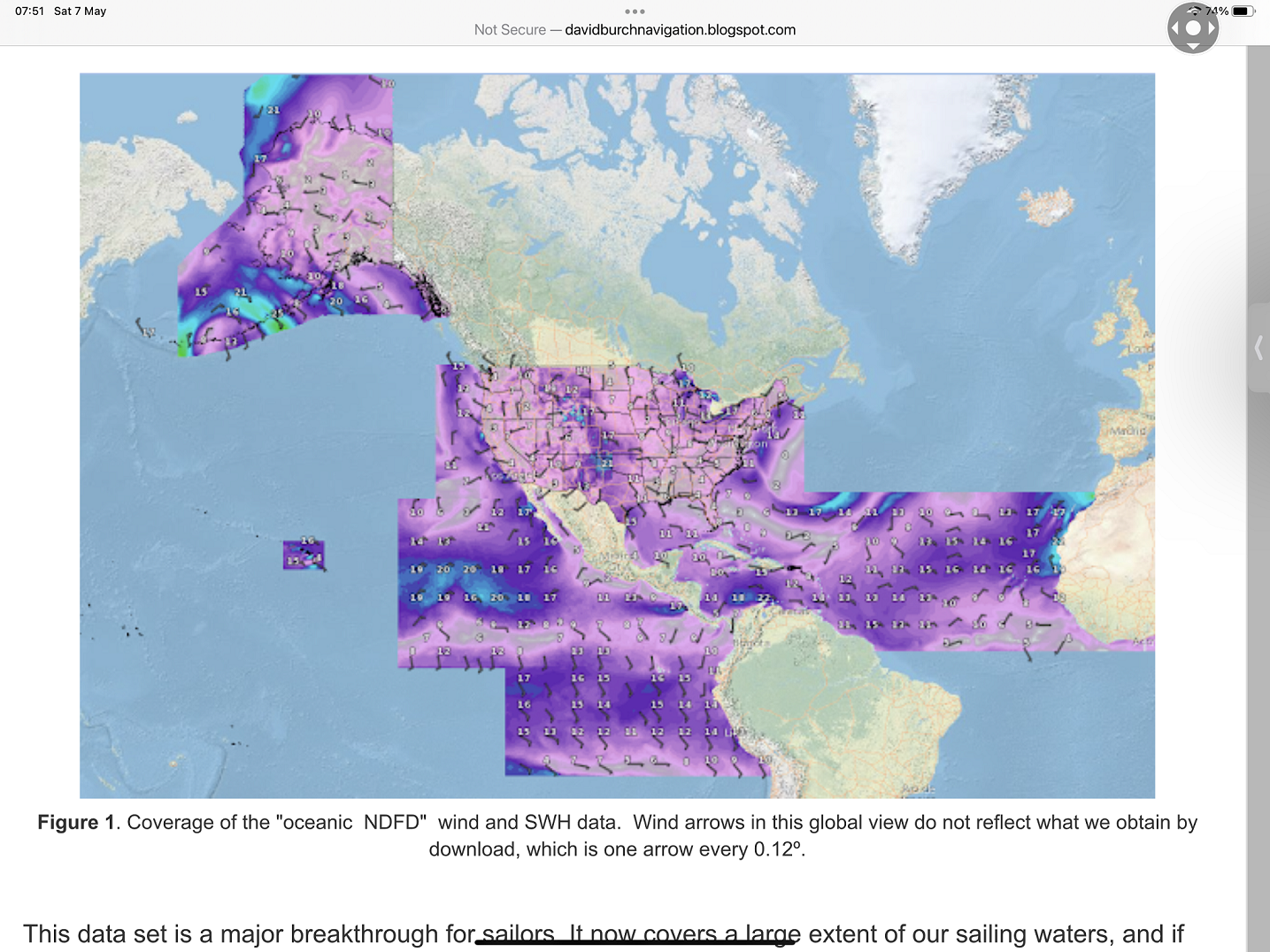
- Output resolution: 0.05 degree, about 5 km, .
Times:
- Forecast period 1-3 days, every 3 hours from 0120.
Parameters
- WIND
- GUST
- WAVES.
A typical request would be:
send NDFD:24N,20N,110W,105W|0.05,0.05|06,3..36|
Code: ECMWF
Data from the ECMWF HRES model are listed in the Catalogue but are only on prepayment. However, a limited amount of data are now �Open Data� and can be freely distributed.
- Resolution: 0.1 degree.
- Available 0.4 degrees
Times:
- 0 to 144 hours at 3-hourly intervals
- 144 to 240 hors at 6-hourly intervals
Approximate update times:
- 0800
- 2000
Parameters:
- WIND (10 metres above surface)
- MSLP
- TEMP (temperature 2 metres above surface)
- HGT500 (500hPa height)
A typical request might be:
send ECMWF:35N,19N,123W,102W|0.4,0.4|0,3..72|MSLP,WIND
The default is WIND.
Code:ICON:
ICON is a global model run by DWD, the German Met service.
- Resolution: 0.125 degree.
- Available 0.125 degrees
Times:
- From 00/12 UTC data, to 180 hours at 3-hourly intervals
- From 06/18 UTC data, to i2o hors at 3-hourly intervals
Approximate update times:
- 0400
- 1000
- 1600
- 2200
Parameters:
- PRMSL (PRessure/Mean Sea Level)
- WIND (10 metres above surface)
- GUST (at 10 metres)
- AIRTMP (temperature 2 metres above surface)
- SFCTMP (temp at sea surface)
A typical request could be:
send ICON:26N,20N,114W,105W|0.125,0.125|0,6..72|WIND,MSLP,SFCTMP,
Code: ICON
Using the same code, there is a higher-resolution regional version. Saildocs will self select the model.
- Area: 29.5N-70.5N and 023.5W-045.0E.
- Output eesolution 0.0625 x 0.0625 degrees (around 7km)
Times:
- 8 tmes daily from 00 UTC, to 120 hours.
- Available 3 hours after data time. Saildocs will select the appropriate data for the requested area.
A typical request could be:
send ICON:46N,51N,5W,16E|0..06,0.06|0,6..72|WIND,MSLP,SFCTMP,
Code: NAVGEM:
NAVGEM is the US Navy model.
- Model resolution: 0.18 degrees
- Available multiples of 1 degree
Times:
- 24 hours, 3-hourly intervals
- 24-96 hours, 6-hourlyintervals
Approximate update times:
- 0600
- 1200
- 1800
- 2400
Parameters:
- PRMSL
- WIND
- HGT (500hPa height)
Code: COAMPS
COAMPS is the US Navy Meso-scale model (LAM). It uses NAVGEM for initial and boundary conditions.
The model is run for:
- NE Pac: 34-64N,172-118w
- So Cal: 22-43N,128-109W
- Eq. Am: 12-32N,122-058W
- W Atl: 20-55N,093-055W
- Euro: 29-66N,015W,040E
- Available om 0.15 x 0.15-deg grid
- Times: to 96 hours (except 72 hrs for w-Atl).
Default parameters
- WIND. The euro model is 96 hours at 6-hour intervals for pressure and wind.
Code: HRRR:
HRRR - High Resolution Rapid Refresh" is a the latest NOAA hi-res forecast model covering the contiguous USA - as shown here.
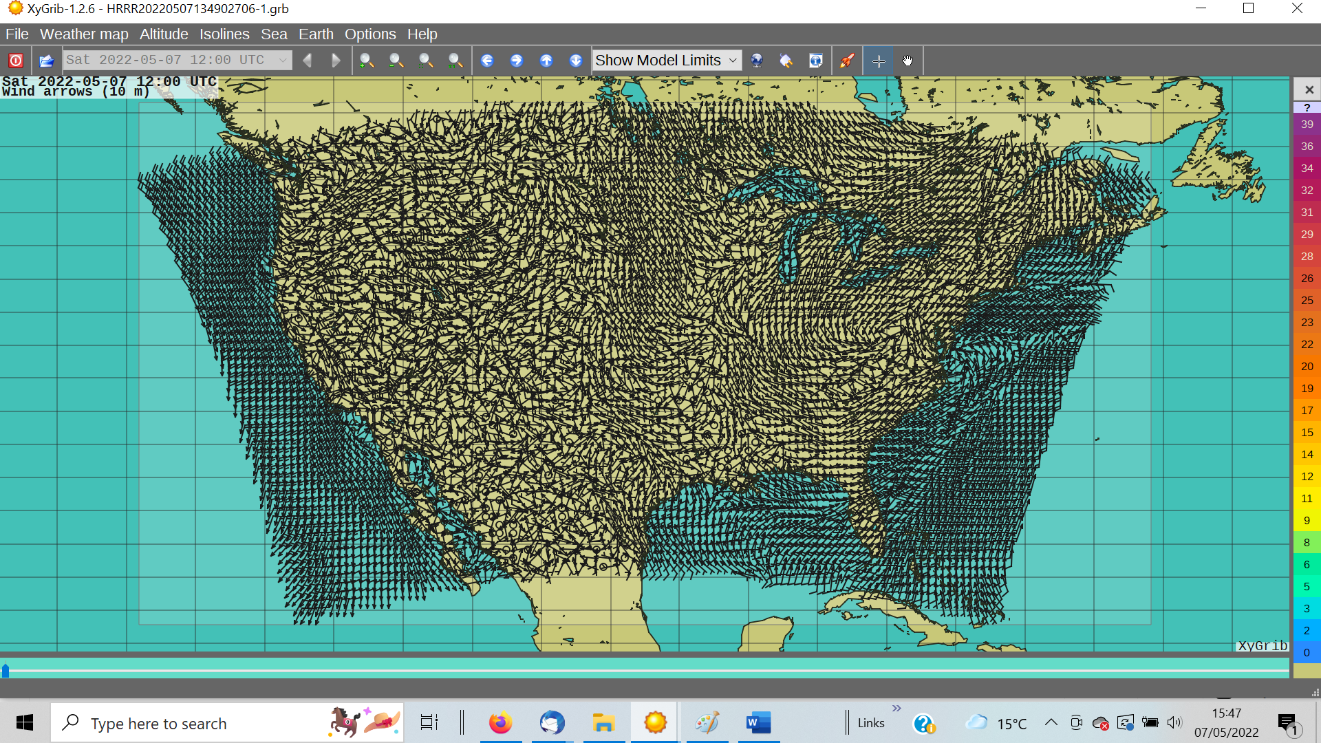
- Resolution: maximum 0.03 degrees.
- Times: hourly forecasts:
- To 18 hours, updated hourly. About HH+1.5.
- To 48 hours, updated 6-hourly at about HH+2
Patameters:
- PRMSL (pressure at sea level)
- WIND (10 metres above surface)
- GUST (10 metres)
- AIRTMP (temperature 2 metres above surface)
- SFCTMP (temp at surface)
- LFTX (Lifted index)
- CAPE (clear air potential energy)
- RAIN (Precip rate, mm/hr)
- APCP (Accumulated precip)
Typical trequest send HRRR:35N,31N,122W,116W|0.2,0.2|0,1..24|WIND,RAIN
Code: RTOFS:
RTOFS is NOAA's ocean current forecasts based on the HYCOM model
- Times: To 72 hours at 3-hour intervals
- Available around 1100
- 72 to 192 hours at 6-hour intervals
- Available around 17:00z.
Parameters:
- CURRENT
- WTMP (Water temperature)
- DSL_M (sea-level deviation)
- and SALTY (salinity)
- ICE (Ice concentration)
- ICETK (icethickness)
The default is CURRENT.
A request might be:
Send RTOFS:55N,30N,80W,70W|0.2,0.2|0,3..24|
Not all GRIB viewers handle RTOFS. Two that will are