
About this page
This is a one-stop guide to forecasts appropriate to different types of sailing.
Preamble
There are many forecasts other than those mentioned here and other pages on this site. Experienced sailors may be able to use and interpret synoptic charts but they cannot give detail well; they are a somewhat crude meteorological shorthand. For sources see my Chart list and Radio Fax pages. While not denying their usefulness, I am suggesting that most sailors will find GRIB data easier to understand and use.
Although primarily concerned with and based on experience in Western Europe and the Mediterranean, Similar services will be found elsewhere.
!!! Day Sailing - Local experience or forecasts?
There are several limitations to what can usefully and meaningfully predicted for a day sailor concerned with small variations in weather over short periods.
- Small scale weather details have short lifetimes. A thunderstorm some 10 � 15 km across my have a lifespan span of around 6 hours. A small cumulus cloud, say 1 km across, my last a few tens of minutes.
- The finest scale numerical weather prediction models use a grid of about 1.5 km. The smallest scale weather can be defined is about 6 � 8 km.
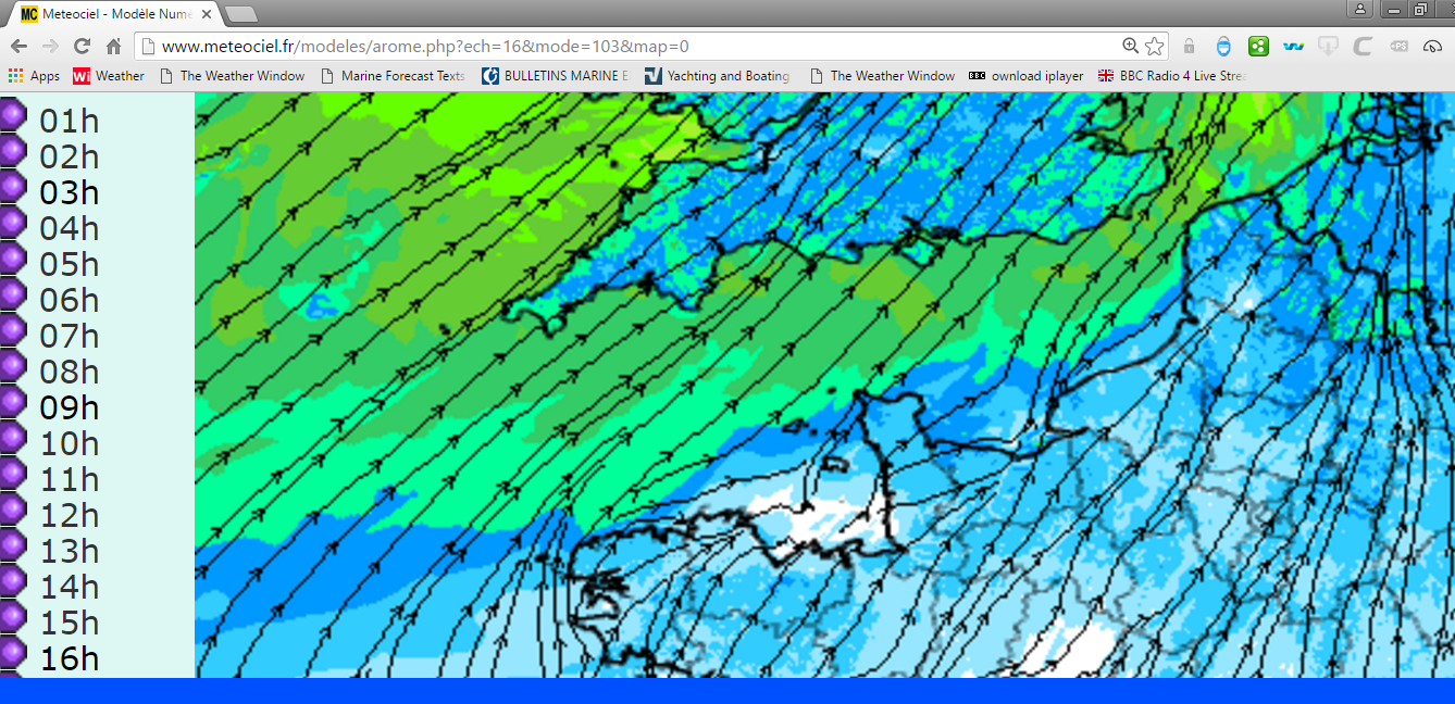
- Displays of fine scale forecasts, eg this ftom the M�t�o France AROME 1.3 km prediction has much detail but still far less than we experience at sea.
- Worded forecasts heard or read can only be general, headlines.
In brief, no forecast broadcast over radio or issued in graphical form can describe weather detail that we observe. At best they will show what may happen rather than what will happen.
Day Sailing Tools
The main source of weather information is on VHF from MRCCs. These provide inshore waters and offshore (shipping) area forecasts written by human forecasters using computer model output combined with their collective experience of bot the area and the models. Although they are very general in nature, they are an essential warning service,
Updating is twice a day at least but 6-hourly by the UK Met Office and Met Eireann for inshore waters. Around the UK (principally) and some other countries, public service radio broadcasts may provide more frequent updates for offshore areas eg the BBC Shipping forecast on Radio 4.
Inshore waters forecasts are broadcast by the UK on NAVTEX 490 kHz twice a day. Otherwise, the Internet is a nearly always available resource particularly with the increasing use of smartphones and tablets. These give access also to GRIB files. These help in interpretation of the necessarily broad-brush broadcast forecasts.
A vital input for local sailing and detail wherever you sail must be your own input � a combination of experience, common sense and native wit.
Coastal Cruising - Planning ahead.
There are two aspects to using weather information for coastal cruising. The first is to use forecasts in order to be in the right place at the right time and to avoid being in an inhospitable port or anchorage in weather that you do not want to go out in. The second is the decision on the day, whether to go or not.
The first involves making decisions, at least tentatively, for as long ahead as is sensible. Currently that is up to about 8 days. The European C entre for Medium range Weather Forecasting (ECMWF) was setup to do just that. They are sufficiently confident to issue forecast synoptic charts to 10 days ahead. Other major, operational centres also run numerical weather models to several days ahead.
For decisions �on the day�, use the day sailing forecasts listed above. Ask �what if� questions such as:
- Can I cope if winds are a Beaufort force stronger?
- Will I reach my destination on time if winds are veered or backed by 30 degrees?
Using synoptic charts is fine for an overall view � should I go today or tomorrow? Will it be OK to stay put for a few days before moving on. However, it is difficult on forecast charts for a few days ahead to get an idea about whether winds will be predominately force 3, 4, 5 or 6. Or whether directions will be SW, W or NW � for example. For a clearer, quantitative idea about what may happen over the next few days, US GRIB Files provide the best answer. Never totally reliable but sufficient to get an idea and allow assessment of risk.
Over my years as a cruising yachtsman I have learned to look at forecasts for the next 10 days on a daily basis and look for consistency in successive forecasts. This is an example of nine forecasts on successive days from 30 August to 7 September all for the day of 7 September for a point in mid-Channel.
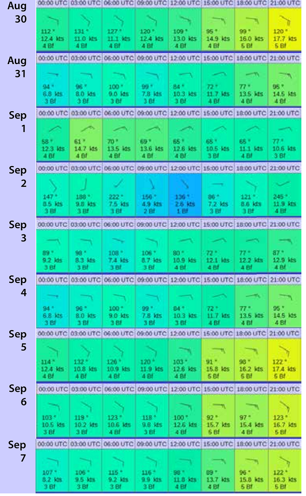
With this degree of consistency there ws high confidence by 1st or 2nd September that the weather on the 7th the 7th would be OK for a crossing St Peter Port to Dartmouth. On the morning of the 7th, at 0630 we had every confidence in the forecast for our crossing.
A truly independent check could have been the DWD RTTY broadcasts or the same information as a three-day forecast at Route Channel to Gibraltar.
Other sources of forecasts for the next few days are the VHF MRCC broadcasts ; French MRCCs, in particular, sometimes include brief outlooks for a few (up to 5) days ahead. The UK NAVTEX 3 - 5 day extended outlooks are on NAVTEX 518 kHz. The UK, alone, gives these extended outlooks in a dedicated broadcast, texts are on the Internet.
Blue Water Sailing - Climatology and warnings.
Blue Water Sailors plan on the basis of climatology, and, when they are on passage, there is little that they can do to avoid bad weather. Unless, that is, they are super yachts capable of 15 to 20 knots or more. A vessel doing less than 200 miles or so a day cannot be weather-routed usefully for more than a few days ahead; the boat is too slow and storm systems are too large, coupled with the inherent uncertainty in predicting the track of a storm.
A 6 or 7 day forecast is, very obviously, useful to help decide on which day to leave port; there is no point in running into bad weather when you are still near land.. After that, these are not a great deal of use except to advise of severe weather and give time for preparation. The more knowledgeable blue water sailors study forecasts and charts while on passage in order to seek an optimum route. How effective they are is uncertain. Equally uncertain is the value of advice from people onshore, however experienced. My own experience with weather routing ships was that it was very difficult to provide useful advice to a ship doing 10 knots. Given the constraints on a sailing yacht, it must be even more difficult.
This opinion was confirmed by a well-known round-the-world racing navigator who also sailed a 12 metre (40 foot) cruising yacht. A better service might help, if only psychologically, but, that is a long way from storm avoidance.
Blue Water tools.
For decisions on which day to depart, use the appropriate forecasts from the Coastal section above.
Inmarsa/Iridium EGC provide the GMDSS service covering the globe between about 60 degrees north and south (Inmarsat) and globally (Iridium) . For texts online, see HF/SSB broadcasts in voice from Monaco Radio for the Mediterranean and the Eastern Atlantic, also US HF/SSB for the Western Atlantic.
Email via Marine HF or HAM can be used to access the US GRIB files forecasts. For HAM use, Winlink provides many services.
[[http://www.nws.noaa.gov/om/marine/hfsitor.htm |
RadioFax is slow but this is not necessarily important on a long passage. Around Europe use either the DWD or RN Northwood broadcasts. Eewhere in the world refer to the NOAA Guide to world-wide radio-fax broadcasts.
I am sometimes asked about routing from onshore services, Unless they have a direct line to the Almighty, such services can only use forecast output from the major National Met services although they can look at several such so as to give a consensus view, In that sense they are useful but whether they are more so than the informed on-board use of GRIB coded forecasts and/or RadioFax charts will depend on the individual sailor. The comments above regarding the difficulty in giving useful routing advice to a slow moving yacht still holds whoever is doing the interpretation.
Additions and Corrections
This page is not intended to be exhaustive and should be taken as a starter page. Serious omissions and any corrections received will be implemented as soon as possible.
This page was produced initially at the suggestion of the OCC as a quick guide to what forecasts can be used for different types of sailing.