About this page
Notes on weather in the Mediterranean based partly on experience and observation plus some text book input. These notes were written, originally, after our first experience of sailing in the Western Med and revised slightly after subsequent years. If that sounds slightly presumptuous, then I should explain that I have talked to the Forecasters at Gibraltar and, of course, studied the Admiralty Pilot. Anyone wishing to see how we found the area can find my logs elsewhere on this site.
Related pages
Forecast texts Mediterranean Sea Areas Italian Sea Areas
On this page -
- General Description
- Thunderstorms and Waterspouts
- Katabatics W Med
- Katabatics Adriatic
- Forecasting them
- Sea and Land Breezes
- Gibraltar Strait
- Other Winds
- Forecasts
General
Mediterranean weather, in general, is not easy to understand. In these latitudes weather systems are often weak looking to our eyes, accustomed as we are to Atlantic lows developing through a recognisable life cycle, often with strong pressure gradients and well-marked fronts.
In the Summer half of the year there are few large, vigorous depressions in the Med. However, winds are often surprisingly strong. This is partly because of the Coriolis effect which, for a given pressure gradient, results in stronger winds in low latitudes and lighter ones. Minor changes in the pressure pattern can give markedly different winds and weather. Shallow, rather weak and small depressions can give locally very strong winds. This is especially true of small lows forming in association with thunderstorms.
Depressions arrive in the Winter from various sources. Some come from the Atlantic, across France or through the Gibraltar Strait. Others form near the Baléares or the Gulf of Lions. Most of these moves towards the Gulf of Genoa. Some from the Baléares move east to the north of Sicily. Another source of Winter lows is the area to the south of the Atlas Mountains. Some of these lows approach the Gulf of Gabčs and then turn NE towards Malta and the Tyrrhenian Sea.
Much of the weather in the Summer is determined or largely influenced by local effects - katabatics, sea breezes and other topographic forcing. Lows form in the Gulfs of Lion and Genoa particularly. These usually result in Mistral or Tramontanas. Sometimes low pressure areas developing over Spain can spawn lows near the Baléares or move up here from North Africa. These can give much cloud and heavy, thundery rain.
Thunderstorms and Waterspouts
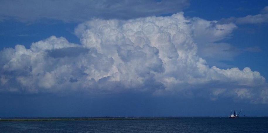
With strong heating, vigorous convection is always possible. The warm water will ensure that there is always plenty of latent heat. thunderstorms will be the result. These can be massive and dangerous. This one is far from the largest that we saw.
The potential for damage due to lightning is obvious.
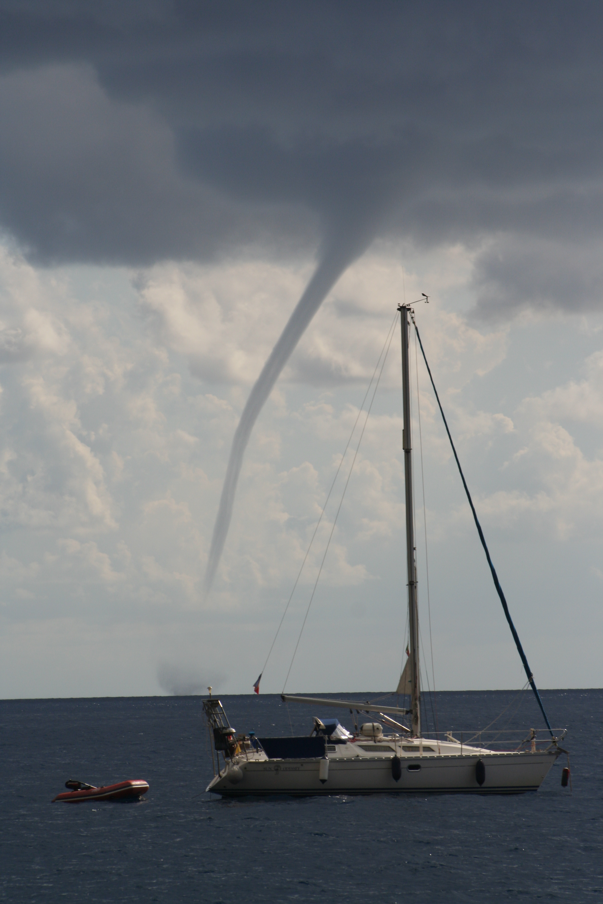
Vigorous convection can lead to waterspouts just about anywhere. This one was seen in the Aeolians (acknowledgement to Matt Booney)
We saw four in one year all around the Baléares. Frightening, to put it mildly.
If there is any mention of thunderstorms, keep a careful weatch both by eye, listening to and reading forecasts. The. Cape index is a useful tool for assessing or, at leats, getting an idea on the intensity of convection and, thus, an indication of risk.
Major Katabatic Effects Western Med
The strong winds known as the Mistral, Maestral, Tramontana or Tramontane, depending on locality, result when a North or Northwest flow breaks into the Med over the Alps or Pyrenees. This may be after a cold front has crossed France and Northern Spain. The NW'ly is often enhanced by a low forming in the Gulfs of Lion or Genoa. Once established these strong winds often last for several days - or as long as the NW air stream persists. Local folk lore suggests that Mistrals occur in multiples of three days. There is no physical reason to support this idea and Mistrals are likely whenever pressure is high over Northern France or Biscay. Thus, prolonged fine weather over Southern England and Northern France may well be accompanied by persistent Mistrals. Crossing the mountains, the air descends on the southern side of the high ground. As a result, it gains speed. This well known physical effect, the conservation of potential energy to kinetic energu, is part of the explanation for the strong wind, sometimes up to Beaufort F 9 or 10.
In the case of the Maestral, the wind is also funnelled down the Rio Ebro valley. The Tramontane crosses the mountains near the Franco-Spanish border through the Toulouse Gap. The Mistral is funnelled down the Rhone valley, the Tramontana into the Gulf of Genoa.
Local topography can play its part. In the Gulf of Valencia a NW gale can become W near Cabo Oropesa and N near Cabo de San Antonio. The air descending from the mountains also becomes very dry (the katabatic effect) and the strong winds are associated with clear or rapidly clearing skies. Mistrals are often very gusty and the sudden increases in wind can appear to be unheralded - "a sudden increase out of a clear sky" is a common description.
The Gulf of Lions Mistral can and often does extend as far as the Bonifacio Strait where it funnels through to give very strong winds indeed. It can also extend to the south of Sardinia.
And in the Adriatic
The Mistral (Maestro) does blow in the Adriatic as a, generally, north or North-westerly wind. It can be strong, up to gale force at times but not nearly as strong as the Bora. This can be a very fierce katabatic wind blowing down off the mountains inland running parallel to the Croatian coast.
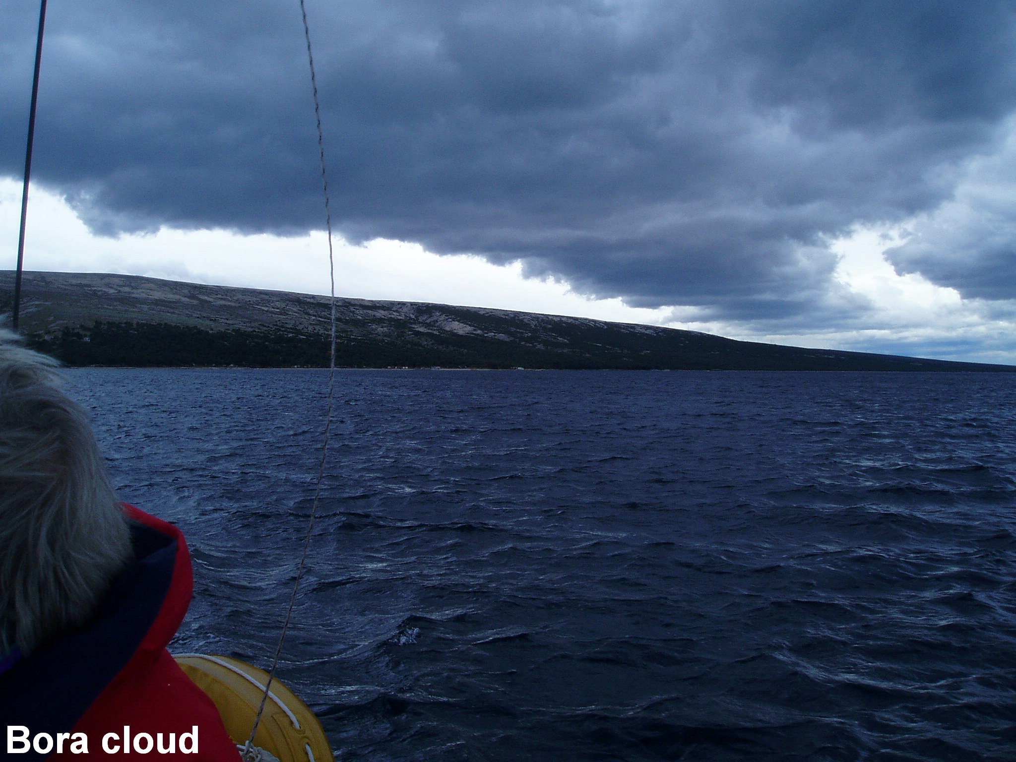
The Bora can occur in various ways. Sometimes a large pool of cold air gets trapped to the east of the mountain range running down the coast. At some stage this spills over and descends to the coast gaining momentum in so doing. The effect may be quite localised or widespread. The weather is normally dry and it can be sunny. Usually there is some orographic cloud oriented parallel to the mountains and sailors become accustomed to recognising the Bora cloud. The large scale weather pattern will usually be a high to the north and low pressure to the south.
and
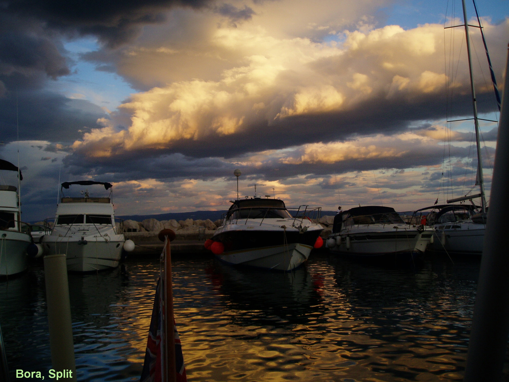
Sometimes a Bora can form after a cold front has passed. Boras around a low pressure area are known as "Black Boras" because they can give substantial amounts of, often thundery, rain and much cloud. Even during early August, we have had to use heating on the boat during a black Bora. In the south of Croatia and Montenegro a Bora type of wind may be known as a Tramontana.
The Bora is often particularly fierce when it comes off the Velebit mountains. The islands offshore here, Pag and Rab especially, have cold very dry air blowing strongly over them for long periods in the winter. Consequently, the vegetation on the eastern side of these islands is parched. Any trees are extremely stunted.
Other areas where the Bota blows strongly are around Trieste and down the valley to Dubrovnik. However, strong Boras can occur almost anywhere. The careful sailor makes sure that he is in port before the Bora arrives.
Predicting these winds
Paradoxically, despite the usual folklore about sudden and unexpected blasts of wind, the conditions for these katabatic winds are straightforward to predict. Warnings are based on the Numerical Weather Prediction model output from the UK Met Office, the DWD, Météo France and the European Centre for Medium Range Forecasts. One of the results of recent advances in numerical weather prediction is that Mistrals, Tramontanas, Tramontanes and Boras are now forecast with considerable and impressive accuracy. Any sailor who ignores these warnings is asking for trouble.
Forecast charts from these major centres are clearly useful but, more user friendly are the 5-day forecasts broadcast by the DWD RTTY for the Western Med and Eastern Med. Perhaps GRIB coded forecasts from the USA will be even more useful. It foes without saying that local forecast services should always be monitored.
The Spanish NAVTEX station Cabo la Naő issues gale warnings well in advance and lasting, sometimes, for several days. Inshore waters forecasts broadcast by CROSS on VHF include "phenomenon important", typically for two days beyond the normal forecast period. Both services may, thus, give warnings of Mistral type winds four or five days ahead. See another page for information on forecasts.
Sea and Land Breezes
With strong heating and hill sides facing the sun the sea breeze must be an important phenomenon. However, like much in meteorology, nothing is quite that simple.
On the Costa del Sol on apparently favourable days, despite plenty of sun to heat south facing slopes, the sea breeze may be either non-existent or very feeble and short-lived. This is probably due to the proximity of North Africa. The North African heating is very powerful and likely to swamp that of the Costa del Sol so inhibiting sea breezes on that coast.
From the Costas Blanca northwards, unaffected by Africa, the sea breeze is far more obvious. Near Dénia, for example, almost regardless of the morning wind, the sea breeze often sets in around early to mid-afternoon from a SE direction. Sometimes it lasts for a few hours and reaches a good F 6 or even 7. Here, the local strength can be affected greatly by the fierce looking Cabo de San Antonio. At other times it dies out fairly quickly and only just gets to a F 4. Approaching Dénia from the Baléares, we have found the sea breeze some 15-20 miles off the Spanish coast. In terms of local time it seems to come in fairly late in the day, perhaps 1600 or 1700 hours. However, it must be remembered that this is only 1400 or 1500 in solar time i.e. only 2 hours or so after solar noon. It may still seem to be late in the day, given the intensity of the heating,
Around Corsica and Sardinia, sea breezes seem to develop rather earlier - any time after noon LT. Around these islands, the heating causes a lowering of pressure over the land. The sea breeze is likely to manifest itself as a SE wind but the sea gets very warm in these areas and the land has to get very hot for the necessary pressure difference to develop. along the east coasts, a NW down the West coast etc. This is, probably, why Italian sailors prefer to circumnavigate Sardinia in an anticlockwise direction. Around the relatively small Baléares, we did not find strong sea breezes. If anything, the effect was to modify the existing wind to make it flow cyclonically around each island as though there were low pressure over its centre. A NE wind along the east of Mallorca would become SE during the afternoon. A light wind along the south of Menorca would become a westerly. And so on.
In the Adriatic, the large scale sea breeze effect on the Croatian side is a regular phenomenon and often mentioned in forecasts. Its local behaviour will be determined by the many islands and other land features. On the, generally low lying, Italian coast, the | Sea-And-Land-Breezes-Form |classical sea breeze]] is more likely and more obvious. It sets in more or less directly onshore, then veers over a period of two or three hours to be along the coast
I know of no way for the yachtsman to predict just how the sea breeze would behave on any given day. There must be a reason or reasons but not necessarily obvious ones. The forecasts by the Spanish and French Met Service do sometimes indicate how strong the sea breeze might be. But they are far from perfect!
At night in most of the western Med an offshore wind is common at night. This can be enhanced down valleys or into bays. Even by dawn, we rarely found it to be strong, just enough so to give a false impression of the wind during the subsequent day.
Winds in the Gibraltar Strait and along the Costa del Sol (Levanter and Poniente)
A major weather problem at or near Gibraltar is whether the wind through the Strait will be W (Poniente) or E (Levanter) - and, of course, how strong through the narrowest part opposite Tarifa where it frequently reaches F 7 or 8. The winds through the Strait are a good example of topographic forcing. Basically, the wind has little option but to flow through the narrows. But, in which direction and how strong?
The predictor is the pressure difference between places to the east and west of Gibraltar. If pressure is higher near Sotogrande or Estepona, say, than near Tarifa, then the wind will be easterly. Conversely, if it is higher near Tarifa, then the wind will be westerly. The greater the pressure difference the stronger the wind. Armed with the Bracknell or Offenbach five-day forecast charts it is possible to predict winds through the Strait several days in advance. Again, the Offenbach forecasts on RTTY are a convenient source of information.
Alternatively, pay your Ł17, or so, and take advice from Gibraltar Met Office, they are very experienced and very good at interpreting the Bracknell charts. However, even Gibraltar Met will be far from precise - it only needs a slight error in the pressure difference for there to be a marked error in the strength of the predicted winds.
Another topographic effect at Gibraltar is that, often during a Levanter, winds in the harbour area are anomalously strong and very gusty. This is particularly marked in the way in which the winds increase at night. This is the converse of what we experience in the UK. Normally, night time cooling causes a stable layer near the ground. This inhibits mixing with the air higher up and moving at gradient speeds. Surface friction slows down the lowest level of air so that the surface wind will be very light and, in extreme cases, even calm, while the gradient wind may be as much as 30 kn. Heating during the morning causes convection which increases the depth through which turbulent mixing occurs. This results in the surface wind increasing.
At Gibraltar, the night time cooling and the subsequent stable layer also cuts off the mixing effect. In this case, however, this allows the surface air to be accelerated by the topography of the Rock while preventing slowing down due to mixing with the slower moving air higher up. During the morning, the sun's heat creates greater mixing and, so, slows down the air movement at the surface.
Other Regional Winds
Vendavales . These strong SW winds, a variant on the Poniente, occur between Southern Spain and Africa in the Winter half of the year, especially in late Autumn or early Spring. They result from lows moving into the Med across Spain or Southern France. Although not very strong, their onset is often associated with squalls and thunderstorms.
Libeccios . These are similar to Vendavales but occur off the south of Sardinia.
Levante. This is the general name given to strong E-NE winds around Spain and caused typically by a low near the Baléares and a high over Europe. They are particularly frequent in the area of Valencia.
Sirocco. These are caused by lows moving east across North Africa. Typically, it is a very hot wind and can be very dry. However, it soon picks up water from the sea. A strong Sirocco will pick up dust from the Sahara and lead to multicoloured rain. The east of Sardinia and the Spanish coasts from Almería to Cabo la Naő are particularly prone.
The Tramontana of Croatia is similar to the Bora but blows more from the north than the north-east. It is not usually as strong.
Availability of Weather Forecasts
Weather forecasting is a science, although still far from perfect. The yachtsman can ignore the experts but does so at his peril. The prudent skipper will listen to all the available advice and then, as ever, apply his own good sense born of experience. I have listed most Marine Weather Information sources on another page. For more specific information broadcast in English, or easy to understand French and Spanish go to my Med Forecast page. .
This list is neither exhaustive nor definitive. I hope that it will be a useful starting point for those following in our wake.
Go to my Mediterranean forecasts page or the GMDSS Pages for Internet links to forecast information in the Western Mediterranean and elsewhere.


